
 English
 Français

Wardleworth railway station
Wardleworth railway station served the township of Wardleworth in Rochdale, in the Metropolitan Borough of Rochdale in Greater Manchester, England, from 1870 until closure in 1947. It was on the Facit Branch between Rochdale and Facit, which was extended to Bacup in 1881. The station was quite well placed for Rochdale town centre and so, in addition to the branch trains, a few other services from Manchester terminated here. Between here and Rochdale station was the Roch Valley Viaduct, now demolished.
Nearby Places View Menu
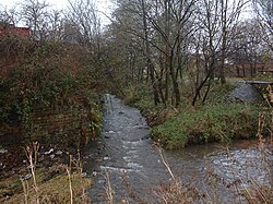
560 m
Hey Brook
Hey Brook is a watercourse in Rochdale, Greater Manchester and a tributary of the River Roch. It originates at the confluence of Buckley Brook and Syke Brook, and flows through Wardleworth to the River Roch.

582 m
Wardleworth
Wardleworth was a township at the geographic centre of the parish of Rochdale, in Salford hundred, Lancashire (now Greater Manchester), England and later a separate civil parish. The principal estate of the township was Buckley. Though the administrative territory has long been abolished, the name continues as a geographic reference frame for that part of Rochdale.
Wardleworth was a township that included territory to the northeast of the town of Rochdale, including the hamlets of Buckley, Crankey Shaw and Hamer Fold, and, although close to the village of Wardle, Wardleworth did not contain the settlement, which was instead within the neighbouring township of Wuerdle and Wardle.
The Buckley and Entwistle families are recorded to have been the principal landowners of this township, with Buckley Hall being the seat of the estate holders for many years.

612 m
Stanney Brook
Stanney Brook is a watercourse in Greater Manchester, England. It originates in the Burnedge area of Shaw and Crompton, and flows through Milnrow into Rochdale before joining the River Roch at Newbold Brow.
Alone among the watercourses of Milnrow and Newhey, it does not pass through the centre of either village, and flows directly into the River Roch, rather than first into the River Beal. Its name derives from the Lancashire dialect word "stanner", a ridge of stones. It is also unusual in that the borough in which it rises, changes, depending on the wetness of surrounding moorland.
The brook drops 100 metres in a little over 5.5 kilometres, or 330feet in 3.5 miles. It is culverted four times, generally is only 60 cm (2 ft) wide, and rarely exceeds 90 cm (3 ft) in width at any point.

615 m
Hope Chapel and Parson's House
Hope Chapel and Parson's House are adjoining Grade II* listed buildings on Hope Street and Wilson Street in central Rochdale, Greater Manchester, England. Built in 1810 and extended in 1848 and 1887, the complex is an outstanding example of a Nonconformist Baptist chapel and its associated minister's residence from the Georgian era. It reflects the religious, social, and architectural developments of early 19th-century Rochdale during the Industrial Revolution. Today, the buildings serve as a heritage and community centre.