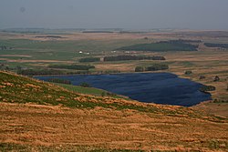
Shap Rural is a very large, but sparsely populated, civil parish in the Westmorland and Furness district of Cumbria in England, covering part of the Lake District National Park. It had a population of 119 in 2001, 130 at the 2011 Census, and 110 in 2021. Within the parish are the hamlets and settlements of Wet Sleddale, Hardendale and Swindale, most of the Shap Fells range and the reservoirs of Haweswater (part) and Wet Sleddale. The village of Mardale Green, which disappeared when Haweswater was converted into a reservoir in the 1930s, was in the parish. The parish was created in 1904 with the splitting of the former civil parish of Shap into urban and rural parts. Shap Urban, (since 1935 just Shap), was administered by an urban district council from 1905 to 1935. Shap and Shap Rural today have a joint parish council. Major landowners in the parish are the Lowther Family Estates and United Utilities. Junction 39 of the M6 motorway lies within the parish. Shapbeck Limestone quarry owned by Heidelberg Materials UK is in the northern part of the parish though the Hardendale Corus limestone quarry and works and the famous Cemex (formerly RMC) Shap Granite quarries and works are within both Shap Rural and Shap parishes. The cottage owned by Uncle Monty in the cult 1986 film Withnail & I is located by the reservoir at Wet Sleddale.

Nearby Places View Menu
Location Image
939 m

Sleddale Hall

Sleddale Hall is a farmhouse on the north side of the Wet Sleddale valley near Shap in Cumbria, England. It featured as "Crow Crag", Uncle Monty's Lake District country cottage in the cult film Withnail and I.
Location Image
1.2 km

Seat Robert

Seat Robert is a hill in the east of the English Lake District, south west of Shap, Cumbria. It is the subject of a chapter of Wainwright's book The Outlying Fells of Lakeland. It reaches 1,688 feet (515 m), and has a cairn and an Ordnance Survey "ring" at ground level rather than the usual trig point column. Wainwright's route is a clockwise circuit from Swindale reaching Seat Robert by way of Langhowe Pike at 1,313 feet (400 m) and Great Ladstones at 1,439 feet (439 m), and continuing over High Wether Howe at 1,705 feet (520 m) and Fewling Stones and 1,667 feet (508 m). The first section of his route follows the Old Corpse Road, a corpse road, along which corpses were carried from Mardale to be buried at Shap.
Location Image
1.8 km

Wet Sleddale Reservoir

Wet Sleddale Reservoir is an artificial reservoir set amongst the Shap Fells 4 kilometres (2 mi) south of the village of Shap in Cumbria, England, and lies just within the boundary of the Lake District National Park. The triangular shaped reservoir, which can store 2,330,406,000 litres (512,618,000 imp gal; 615,628,000 US gal) of water, was created by the construction of a dam across Sleddale Beck in order to supply Manchester with water. The dam is 21 metres (69 ft) high and 600 metres (2,000 ft) long. The extracted water is carried to Haweswater, mainly through tunnels. The beck emerges from the foot of the dam as the River Lowther. There is a public car park beneath the dam from which a public right of way gives access to the south side of the reservoir. Alfred Wainwright describes a walk from here in the Wet Sleddale Horseshoe chapter of his The Outlying Fells of Lakeland. Manchester Corporation were given powers to construct the reservoir under the Haweswater Act, 1919 but construction did not start until the 1960s and completion was in 1966.
2.0 km

Wet Sleddale Meadows

Wet Sleddale Meadows is a Site of Special Scientific Interest within Lake District National Park.