


Gwinear–Gwithian est une paroisse civile des Cornouailles, en Angleterre. Elle comprend les villages de Connor Downs, Gwinear, Gwithian, Reawla et Rosewarne.
Location
1 explorer visited this place

4 m
Gwinear–Gwithian is a coastal civil parish in west Cornwall, England, United Kingdom. It includes the villages of Connor Downs, Gwinear, Gwithian, Reawla and Rosewarne. The parish is situated approximately two miles east of Hayle two miles west of Camborne.
For the purposes of local government Gwinear–Gwithian has a parish council and elects councillors every four years. The principal local authority is Cornwall Council. The population of the parish was 3032 in the 2001 census. This included Fraddam and increased to 3,261 at the 2011 census. An electoral ward also exists with St. Erth added to the name. The population here in 2011 was 4,642.

569 m
Gwithian is a coastal village and former civil parish, now in the parish of Gwinear-Gwithian, in the Cornwall district, in west Cornwall, England. It is three miles north-east of Hayle and four miles east of St Ives, Cornwall across St Ives Bay.
In 1931 the parish had a population of 634. On 1 April 1934 the parish was abolished to form "Gwinear Gwithian".
Gwithian has a pub, the Red River Inn, which was formerly named the Pendarves Arms. The pub takes its name from the nearby Red River which, in turn, got its name from the discolouration caused by mining effluent. The river's earlier name was Dowr Coner.
603 m
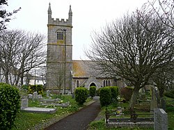
St Gothian's Church, Gwithian is a Grade II* listed parish church in the Church of England Diocese of Truro in Gwithian, Cornwall, England, UK. Nothing is known about St Gothian, Gocianus or Gwithian.
1.2 km
St Gothian Sands is a Local Nature Reserve near Gwithian, Cornwall. It was declared a Local Nature Reserve in 2005 by the Penwith District Council.

1.3 km
The Red River is a small river in south-west Cornwall, England, United Kingdom which issues into St Ives Bay at Godrevy on Cornwall's Atlantic coast. The Red River was given its name from the mineral deposits associated with tin mining, particularly oxides of Iron, which formerly coloured its water red. The river's gradient is relatively steep; over its 8 miles length, it falls 170 metres from source to sea.