


Grit Fell is a lonely hill between Clougha Pike and Ward's Stone in the Forest of Bowland in Lancashire, England. Covered by heather and large bogs, it is difficult walking country. The path from Jubilee Tower car park in the south is difficult and treacherous, with sheer-sided bogs 6 feet (1.83 m) deep.
Location
2 explorers visited this place

1.5 km
Clougha Pike is a hill in the Forest of Bowland in Lancashire, England. From the west it looms over the Conder Valley, the city of Lancaster and Lancaster University. It is visible from as far away as Barrow-in-Furness, South Lakeland mountains such as the Old Man of Coniston, and Blackpool Tower. From the west, it appears to be a large dome shape, with a cliff-like section at the very top. From the south-west, a series of notches or cloughs are visible in its flanks, giving the hill its distinctive name. The notches vary in size and run across the side of the hillside, but not down it. The largest notch has had part of its floor filled in by a small lake and swamp and is a dramatic gritstone boulder-strewn feature. These notches are thought to have been cut by meltwater flowing south-west from the area of Littledale, along the side of a glacier which occupied the Quernmore valley. They are known as marginal notch channels and are among the best examples of these features in Britain.
Clougha can be reached from the west, by a pleasant path that travels up its slopes by Rowton Brook and then diagonally up the final steep broken rock section. It can also be reached from the east from Grit Fell, over boggy land along a muddy path that is sometimes difficult to distinguish. An approach from the north, from the direction of Caton, is also possible. A small car park is also available close to Clougha Pike, just off Rigg Lane. Another starting point to ascend Clougha is from the Victorian folly of Jubilee Tower, where there is also a car park.
Its summit furniture includes an Ordnance Survey trig point and two rock wind shelters. The view west from the top is over Morecambe Bay. On a clear day views from Clougha Pike extend to Snowdonia, the Ribble Estuary, the Isle of Man, the fells of the Lake District and many of the Pennine hills. Very rarely, the Mourne Mountains can be seen to the south of the Isle of Man.
Clougha Pike was one of the lowest of the 100 hills included in Trail magazine's 2007 list of "Britain's Greatest Mountains".

2.7 km
The River Grizedale, also known as Grizedale Beck, is a river in Lancashire, England.
The river rises at Grizedale Head between Abbeystead Fell, Cabin Flat and Dunkenshaw Fell and flows southwards, picking up several small streams on its way. Grizedale Beck is used as a nursery for juvenile salmon and trout. It flows through the Grizedale Reservoir, continuing southward and joining the river Wyre north east of Garstang.
3.4 km
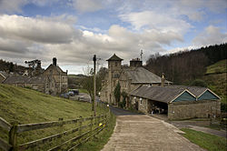
Littledale Hall is a former country house in the civil parish of Caton-with-Littledale in Lancashire, England, some 10 miles east of Lancaster. It is recorded in the National Heritage List for England as a designated Grade II listed building.
It dates from 1849 and, in the absence of documentary evidence, its design has been attributed on stylistic grounds to the Lancaster architect E. G. Paley. It is constructed in sandstone with slate roofs, and is in Gothic style.

3.5 km
Ward's Stone is the highest hill in the Forest of Bowland, England. Its flat top hides two trig points nearly a kilometre apart. The western trig point sits atop of large rocks, including one, the Ward's Stone, that is so large it attracts boulderers and climbers.
The path from Grit Fell is difficult: crossing Cabin Flat, it weaves its way across hidden pools of stagnant water, the presence of which is betrayed by a form of red grass. White markers supposedly point out the way, but more often result in leading the walker astray. The second trig points faces the empty vastness of the eastern Forest of Bowland, with the summits of Wolfhole Crag, White Hill and the distant Ingleborough breaking the horizon. A second path approaches Ward's Stone from Tarnbrook, where limited parking is available.
On the southern slope of this hill are Thorn Crag, Hell Crag and Long Crag, rocky outcroppings that are popular with climbers. Within Thorn Crag, a shallow cave system exists that leads to Hell Crag; this route was first traversed by Lancaster University Mountaineering Club.
3.6 km
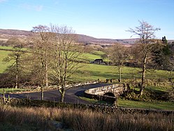
Grizedale Bridge is a Grade II listed bridge in the English parish of Over Wyresdale, Lancashire. The structure, which dates to the 19th century, carries Rakehouse Brow over the River Grizedale. A Grade II listed structure, it is in sandstone and consists of a single elliptical arch and has a solid parapet with a rounded top.
The path from Clougha Pike in the west is better, but still contains bogs crossed by the odd plank of wood. The path from Ward's Stone is the most treacherous of all. Crossing Cabin Flat, it weaves its way across hidden pools of stagnant water, the presence of which is betrayed by a form of red grass. The summit is fairly inconspicuous, with only cairns and a wall.