


Barmby railway station was a station on the Hull and Barnsley Railway, and served the village of Barmby on the Marsh in the East Riding of Yorkshire, England.
Location
2 explorers visited this place

889 m
The Church of St Helen, Barmby on the Marsh, East Riding of Yorkshire, England is a redundant church which is now in the care of the Friends of Friendless Churches. The church is recorded in the National Heritage List for England as a designated Grade II listed building.

1.0 km
Barmby on the Marsh is a village and civil parish in the East Riding of Yorkshire, England. It lies about 4 miles west of the market town of Howden. It lies on the east bank of the River Ouse, near its confluence with the River Derwent.
According to the 2011 UK census, Barmby on the Marsh parish had a population of 372, an increase on the 2001 UK census figure of 345.

1.3 km
The Long Drax swing bridge was a swing bridge on the River Ouse near Barmby on the Marsh and Drax, built in the 1880s for the Hull and Barnsley Railway. The bridge was dismantled in the late 1970s.

1.6 km
Long Drax is a small hamlet and civil parish in the county of North Yorkshire, England, about 2 miles north-east of Drax. In 2011 it had a population of 125.
The settlement consists of a linear string of houses along the bank of the River Ouse, as well as several scattered farms.
To the west of Long Drax is the site of Drax Priory. Founded in the 1130s, the Priory was dedicated to St. Nicholas and is believed to have been moated. It was subsequently destroyed during the Dissolution of the Monasteries in 1535. A farmhouse was built on the site in the 18th century and later became a meeting place for Quakers. The site is now known as Drax Abbey farm and has been a scheduled monument since 1964.
The village was historically part of the West Riding of Yorkshire until 1974. From 1974 to 2023 it was part of the district of Selby, it is now administered by the unitary North Yorkshire Council.
Drax Power Station occupies a large area in the south-west of the parish.
1.8 km
The Derwent is a river in Yorkshire in the north of England.
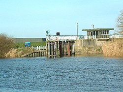
It flows from Fylingdales Moor in the North York Moors National Park, east then southwards as far as its confluence with the River Hertford then westwards through the Vale of Pickering, south through Kirkham Gorge and the Vale of York, joining the River Ouse at Barmby on the Marsh. The confluence is unusual in that the Derwent converges on the Ouse at a shallow angle in an upstream direction.
The river used to flow further east, its old course entering the Ouse east of Howden.
The River Derwent catchment area includes the Upper Derwent, River Rye, River Hertford, Bielby Beck and Pocklington Canal and their tributaries. It covers an area of 2,057 square kilometres and includes the towns of Stamford Bridge, Malton, Pickering, Helmsley, Filey and Scarborough. The area is bounded by the Cleveland Hills, North York Moors and Hambleton Hills to the north, the Yorkshire Wolds and the coast to the east, the Vale of York to the west and the River Ouse and Humber Estuary to the south. The area around the river is primarily rural in nature with grazing moorland in the upland areas and a variety of agricultural uses at lower levels. There are large areas of designated conservation sites throughout the area. There are two titles named after the River Derwent in the British peerage, Viscount FitzAlan of Derwent which is extinct and Baron Derwent.
References
Butt, R. V. J. (October 1995). The Directory of Railway Stations: details every public and private passenger station, halt, platform and stopping place, past and present (1st ed.). Sparkford: Patrick Stephens Ltd. ISBN 978-1-85260-508-7. OCLC 60251199. OL 11956311M.