
 English
 Français

Eglinton Country Park
Le Eglinton Country Park est un parc situé sur le terrain de l'ancien château d'Eglinton à Kilwinning (North Ayrshire, Écosse). Le Eglinton Park se trouve dans la paroisse de Kilwnning, qui faisait partie de l'ancien district de Cunninghame, et couvre une surface de 400 hectares (dont 40 de forêt). La partie centrale du parc est marquée par les ruines du château d'Eglinton, qui appartenait à la famille du même nom puis plus tard à la famille Montgomery, comtes d'Eglinton et chef du clan Montgomery. Le Eglinton Country Park est géré et maintenu par le conseil de North Ayrshire et des Rangers.
Nearby Places View Menu

2 m
Eglinton Country Park
Eglinton Country Park is located on the grounds of the old Eglinton Castle estate in Kilwinning, North Ayrshire, Scotland (map reference NS 3227 4220). Eglinton Park is situated in the parish of Kilwinning, part of the former district of Cunninghame, and covers an area of 400 ha (990 acres) ([98 acres (40 ha)] of which are woodland. The central iconic feature of the country park is the ruined Eglinton Castle, once home to the Eglinton family and later the Montgomeries, Earls of Eglinton and chiefs of the Clan Montgomery. Eglinton Country Park is managed and maintained by North Ayrshire Council and its Ranger Service.
330 m
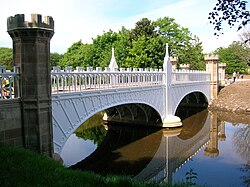
Eglinton Tournament Bridge
The Eglinton Tournament Bridge is a bridge located within Eglinton Country Park near Kilwinning, North Ayrshire, Scotland. The bridge crosses the Lugton Water a short distance northwest of Eglinton Castle (grid reference NS 3206 4224) and was named after the Eglinton Tournament of 1839. The castle and surrounding grounds were once home to the Montgomerie family, Earls of Eglinton and chiefs of the Clan Montgomery.
614 m
Irvine New Town Trail
The Irvine New Town Trail is a recreational cycleway and footpath around Irvine, North Ayrshire, Scotland. The route is 19 kilometres (12 mi) long.
The trail is used by many dog walkers and cyclists in the area.
The route forms a ring with no specific start and end points. Taken in a clockwise direction from the town's main Rivergate Centre, the trail runs beside the River Irvine through Irvine's Low Green, continues north beside the railway line past the Towns Moor and the Garnock Floods wildlife reserve, then goes along beside the River Garnock towards Kilwinning's Woodwynd and Blacklands area. At this point, it diverges from the Ayrshire Coastal Path, crossing the river along the route of the former Doura colliery branch line of the Ardrossan Railway before following the Lugton Water eastwards through Eglinton Country Park: a very popular area for recreational activities, with historical interest at Eglinton Castle.
The trail rejoins the disused Ardrossan Railway line at Sourlie Wood nature reserve, and follows the old track south through Girdle Toll in a cutting which formerly led to the Perceton colliery. The trail then runs beside the Annick Water, initially southwards through parkland and countryside to the east of Bourtreehill. It follows the river west in parkland between Broomlands and Dreghorn, using the disused Glasgow, Paisley, Kilmarnock and Ayr Railway trackbed past the site of the former Dreghorn railway station, then rejoins the River Irvine riverbank heading north back to the Rivergate shopping mall.
The route forms part of the national cycle network with routes 7 and 73 forming part of the route.

826 m
Eglinton Loch
Eglinton Loch (NS 232698 642303) is a small freshwater loch in the North Ayrshire Council Areas (KA12 8TA), lying in a holm of the Lugton Water near Irvine and Kilwinning, within Eglinton Country Park, in the parish of Kilwinning. The loch has 3 small islands within it and is one of a number of Ayrshire's artificial lochs, created by mineral excavation.

853 m
Ayrshire Central Hospital
Ayrshire Central Hospital, also known as Irvine Central Hospital, is an NHS hospital in Irvine, North Ayrshire, Scotland. It is managed by NHS Ayrshire and Arran.