
 English
 Français

Aldingham
Aldingham est un village et une paroisse civile de Cumbria, situé dans le nord-ouest de l'Angleterre.
Nearby Places View Menu

1.5 km
Baycliff
Baycliff is a seaside village in the Westmorland and Furness unitary authority area of Cumbria in England. Historically in Lancashire, it lies 3 miles (4.8 km) south of Ulverston, in the civil parish of Aldingham. At the centre is a village green, and many of its buildings date from the 17th and 18th centuries. The two public houses, the Farmer's Arms and the Fisherman's Arms, stand close to the green.
1.7 km
Scales, Aldingham
Scales is a small village in Westmorland and Furness, Cumbria, England. The town of Ulverston is around 3.5 miles south of the village. The name Scales comes from the Old Norse skali, with an Old English plural *Scalas, meaning huts. It is in the historic county of Lancashire.
The village has a long history, proven when mesolithic human remains were discovered in a cave in a limestone outcrop known as Scales Haggs to the east of the village.
A fragment of gravestone was once discovered in Aldingham Church, which bore an inscription to one Goditha of Scales, who it appears was an abbess and was probably the daughter of the local Lord, Michael le Fleming.
The village was once home to a small local primary school called Aldingham Parochial School, which was closed down in 1994 and amalgamated with two other local schools. The symbol of the three interconnected circles is still clearly visible on the renovated building, now a house.
The village hall, officially called Aldingham Parish Hall is known to locals as The Malt Kiln and would once have been used to dry and ferment locally grown Barley into Malt for use in vinegar, beer and bread making. Until relatively recently, it was possible to see remnants of the old process in the building but it has since been renovated.
2.1 km
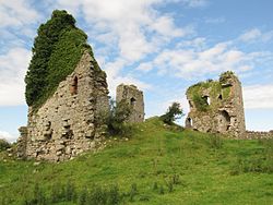
Gleaston Castle
Gleaston Castle is a medieval building in a valley about 1 kilometre (0.62 mi) north-east of the village of Gleaston. The village lies between the towns of Ulverston and Barrow-in-Furness in the Furness peninsula, Cumbria, England. Gleaston Castle has a quadrilateral plan, with a tower at each corner. The largest of these, the north-west tower, probably housed a hall.
The castle was most likely built for John Harington, 1st Baron Harington in the 14th century, replacing nearby Aldingham Motte. Gleaston Castle descended through the Harrington family until 1458 when it passed to William Bonville through marriage and was subsequently abandoned. The castle passed to the Grey family until Henry Grey, 1st Duke of Suffolk was executed for treason in 1554. As a result, Gleaston Castle became royal property before it was bought by the Preston family in the 17th century, and then passed to the Cavendish family.
As the castle was disused from the mid-15th century it fell into dilapidation, and antiquarian depictions from the 18th century show Gleaston in a state of ruin. Though it is not open to the public, it has been the subject of historical and archaeological investigation in the 20th and 21st centuries.

2.2 km
Newbiggin, Furness
Newbiggin is a village on the A5087 road, in the civil parish of Aldingham, in Furness, in the unitary authority area of Westmorland and Furness, in the ceremonial county of Cumbria, England. Historically in Lancashire, nearby settlements include the large town of Barrow-in-Furness, the village of Aldingham and the hamlet of Roosebeck.

2.6 km
Gleaston
Gleaston is a village with a population of around 400 in the Furness area of South Cumbria, situated between the towns of Barrow-in-Furness, Dalton-in-Furness and Ulverston. Historically in Lancashire, the history of the village can be traced as far back as the Mesolithic period and it was the centre of the manor of Muchland in the Middle Ages. Today it is largely a commuter village for the nearby towns, but its past is still visible in the remains of Gleaston Castle and Gleaston Water Mill, which is open as a tourist attraction.