
 English
 Français
Loch Trool
Le loch Trool est un plan d'eau dans la région de Galloway, au sud-ouest de l'Écosse. Il se situe dans la vallée de Glen Trool. Il est la source de la Water of Trool qui se jette dans la Water of Minnoch et la rivière Cree. Il a été le lieu, en 1307, de la bataille de Glen Trool.
Nearby Places View Menu
0 m
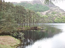
Loch Trool
Loch Trool is a narrow, freshwater loch in Galloway, in the Southern Uplands in south-west Scotland. It lies in an elevated position in Glen Trool in the Galloway Forest Park and is approximately 8 miles (13 km) north of the town of Newton Stewart. The loch is the source of the Water of Trool which flows to the Water of Minnoch and the River Cree. There is a walking trail and footpath around the loch's perimeter.
In April 1307 Robert the Bruce fought and won the Battle of Glen Trool on the shores of the loch. On its north side stands Bruce's Stone which commemorates the victory.
Loch Trool is also reported to be the darkest place in the UK at night.
353 m
Battle of Glen Trool
The Battle of Glen Trool was a minor engagement in the First War of Scottish Independence, fought in April 1307. Glen Trool is a narrow glen in the Southern Uplands of Galloway, Scotland. Loch Trool is aligned on an east–west axis and is flanked on both sides by steep rising hills, making it ideal for an ambush. The battlefield is currently under research to be inventoried and protected by Historic Scotland under the Scottish Historical Environment Policy of 2009.
Robert Bruce had been crowned King of Scots after being involved in the killing of John "the Red" Comyn, a leading rival, a long time enemy, and one of the most powerful men in Scotland, the previous year 1306. Robert the Bruce's rightful claim to the Scottish throne led to a war between King Robert and King Edward I and his allies the Comyns and the MacDougalls.

1.4 km
Glen Trool
Glentrool (Scottish Gaelic: Gleann an t-Sruthail) is a glen in the Southern Uplands, Galloway, Scotland. It contains Loch Trool which is fed by several burns and drained by the Water of Trool. North of Glen Trool is Merrick, the highest mountain in the Southern Uplands. The glen has a visitors centre and campsite.
In April 1307 it was the site of the Battle of Glen Trool.

1.4 km
Silver Flowe-Merrick Kells
Situated in south-west Scotland, the Silver Flowe-Merrick Kells biosphere reserve is composed of two separate sites.
Silver Flowe is a unique bog formation and one of the least interrupted undisturbed mire systems in Europe. Its high value is principally due to the landscape pattern of an assemblage of discrete mires. It is also a breeding site for the rare Azure Hawker dragonfly. Silver Flowe is also designated as Ramsar site.
Merrick Kells contains three habitats of European interest: blanket bog, montane acid grasslands, and wet heath with cross-leaved heath. There are mires supporting various communities, and the area has a wide variety of species but low population levels. There are nationally important breeding bird populations, and important invertebrate populations. The site is the largest remaining unafforested area of upland in Galloway.
Both sites are surrounded by commercial coniferous forestry. The management of Merrick Kells and Silver Flowe is mainly carried out through non-intervention, apart from areas where extensive livestock grazing is practised in order to manage vegetation.
Proposals made in the periodic review for extending this reserve to meet the Seville criteria are being considered.

3.8 km
Loch Valley
Loch Valley is a loch in Galloway Forest Park to the east of Buchan Hill, north of the Rig of the Jarkness and southwest of Craignaw. It drains via Gairland Burn down to Loch Trool.
The loch has a catchment area entirely on the Loch Doon granite, is oligotrophic, and has suffered from gradual acidification since the mid-19th century leading to the elimination of the original Brown Trout population. It has recovered to some extent, with the pH increasing slowly from around 4.4 in 1978 to 5.2 in 2003.
Between 1983 and 2003 the loch's dissolved organic carbon levels increased, and the loch had a sediment accumulation rate of around 0.01 g cm−2 yr−1 from 1850 to 1975.