
 English
 Français

Dungworth
Dungworth (archaic Dungeworth,) is a hamlet in the civil parish of Bradfield, west of Sheffield in South Yorkshire, England. The village also gives its name as a surname; a 'Dungworth' is recorded living at the nearby village of Storrs in 1323. In the late 20th century the English occurrences of the surname remained concentrated in the Sheffield area.
Nearby Places View Menu
708 m
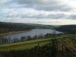
Damflask Reservoir
Damflask Reservoir is situated at grid reference SK277907 five miles (eight kilometres) west of the centre of Sheffield in the Loxley valley close to the village of Low Bradfield and within the city's boundaries. The hamlet of Stacey Bank is located to the east. The reservoir has a capacity of 4,250.9 million litres (1,123.1 million gallons) and has a surface area of 47 hectares (120 acres) with a maximum depth of 27 metres (89 feet). The dam wall is approximately 400 metres (1,300 feet) wide with a height of 28 metres (92 feet).

827 m
Sheffield University Rowing Club
Sheffield University Rowing Club (SURC) is the rowing club for The University of Sheffield and is based on Damflask Reservoir near Lower Bradfield, Sheffield, England, and is affiliated to British Rowing. Based at Damflask Reservoir, within the Peak District, the boathouse used by the club is shared with Sheffield Hallam University RC. The club relies on donations from alumni, competitions and annual membership to care for the upkeep of their boats and equipment.

854 m
City of Sheffield Rowing Club
City of Sheffield Rowing Club is a rowing club on the Damflask Reservoir, based at the Damflask Rowing Centre, Low Bradfield, Sheffield, South Yorkshire, England and is affiliated to British Rowing.

1.2 km
Storrs, South Yorkshire
Storrs is a hamlet within the boundaries of the City of Sheffield in England, 4 miles (6.4 km) west-northwest of the city centre. It is between the suburb of Stannington and the village of Dungworth in the civil parish of Bradfield at a height of 210 metres above sea level between the Loxley and Rivelin valleys. Although historically a farming settlement, water-powered milling on the Storrs Brook and small-scale cutlery making has also taken place in the hamlet.