


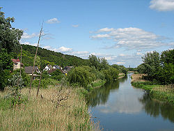
Osinów Dolny [ɔˈɕinuf ˈdɔlnɨ] (German: Niederwutzen) is Poland's westernmost settlement, in the administrative district of Gmina Cedynia, within Gryfino County, West Pomeranian Voivodeship, in north-western Poland, on the border with Germany. It lies approximately 6 km (4 mi) south-west of Cedynia, 50 km (31 mi) south-west of Gryfino, and 70 km (43 mi) south-west of the regional capital Szczecin.
Gallery


Sponsored
Location
1 explorer visited this place
1.7 km
Hohensaaten is a village and a former municipality in Brandenburg in Germany. Since 1 January 2009, it is part of the municipality Bad Freienwalde.

1.9 km
Hohenwutzen is a small village in the state of Brandenburg, in north-eastern Germany, located on the Oder river, on the border with Poland. Since 2003, Hohenwutzen is part of Bad Freienwalde.
It is one of the few villages of the historic Neumark region still in Germany after 1945.
It is the site of a border crossing on the main road connecting Bad Freienwalde, Germany with Chojna, Poland. The adjacent Polish village is called Osinów Dolny - which, when it used to be part of Germany, was called Niederwutzen; the toponyms Hohen- and Nieder- indicate "upper" and "lower" respectively. The name of the Polish settlement is a calque of the old German name.

4.0 km
The Battle of Cedynia was fought on 24 June 972 near the Oder river, when an army led by Mieszko I of Poland defeated the forces of the Saxon margrave Hodo. Whether the battle actually took place near the modern-day town of Cedynia is disputed in modern scholarship.
Mieszko I, Poland's first documented ruler based in Greater Poland, had successfully campaigned in the Cedynia area, then a West Slavic tribal territory also coveted by Holy Roman Emperor Otto I and German nobles. While Mieszko's differences with Otto I were settled by an alliance and payment of tribute to the latter, the nobles whom Otto I had invested with the former Saxon Eastern March, most notably Odo I, challenged Mieszko's gains. The battle was to determine the possession of the area between Mieszko and Odo. Records of the battle are sparse, it was briefly described by the chronicler Thietmar of Merseburg, whose father participated in the battle.

4.1 km
Stary Kostrzynek [ˈstarɨ kɔsˈtʂɨnɛk] is a village in the administrative district of Gmina Cedynia, within Gryfino County, West Pomeranian Voivodeship, in north-western Poland, close to the German border. It lies approximately 8 km south of Cedynia, 53 km south-west of Gryfino, and 73 km south-west of the regional capital Szczecin. Stary Kostrzynek is the westernmost point in Poland.
Before 1945 the area was part of Brandenburg within Prussia, Germany. For more on the history of the region, see New March.
The village has a population of 180. It is the site of a border crossing with Hohenwutzen, on the road connecting the Polish town of Chojna with Bad Freienwalde in Germany.