


The Jonah Warren House, located at 64 Warren Street in Westborough, Massachusetts, is a historic 2½-story wood-frame house. Estimated to have been built in the 1720s, it ranks among Westborough's oldest buildings. The house was constructed along the Old Connecticut Path, a former Native American trail. Jonah Warren, a tanner who moved to Westborough in 1719 and likely built the house, also contributed to constructing the town's first meetinghouse.
Location
1 explorer visited this place

2.1 km
The Vintonville Historic District is a residential historic district to the east of the center of Westborough, Massachusetts. The 20-acre district includes 80 properties on Cottage, Elm, Spruce, Green, Pine, Brigham, Cedar, South, and Beach Streets. The area, which consists of modestly sized houses built on smaller lots mainly between 1860 and 1890, is named for Otis Vinton, who platted out some of the early streets in the area.
The district was listed on the National Register of Historic Places in 2006.

2.2 km
Westborough High School is a public high school in Westborough, Massachusetts, United States that serves as the high school for the Westborough Public School District. The school's mascot is the Ranger, and the school colors are cardinal and navy blue. In the 2022–23 school year, WHS had an enrollment of 1178 students. The school is located in the downtown Westborough area at 90 West Main Street.

2.6 km
Westborough is a town in Worcester County, Massachusetts, United States. The population was 21,567 at the 2020 census, in over 7,000 households. It contains the census-designated place of the same name. Incorporated in 1717, the town is governed under the New England open town meeting system, headed by a five-member elected Board of Selectmen whose duties include licensing, appointing various administrative positions, and calling a town meeting of citizens annually or whenever the need arises.

2.6 km
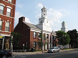
The West Main Street Historic District of Westborough, Massachusetts is an expansive historic district that encompasses a large residential portion of the historic center of the town, as well as part of its commercial center.
When first listed on the National Register of Historic Places in 1987, the district included West Main Street from its junction with Milk and South Streets, west to Blake Street, along with streets running northwest to Whitney Street. It was extended in 1990 to include properties further west on West Main Street, and again in 2006 to include properties south of West Main Street between South Street on the east and Charles and Ruggles Streets in the west, and abutting the Cedar Swamp Archeological District to the southeast. In 2009 it was extended a third time, to include a cluster of streets north of Milk Street and west of East Main Street.
2.6 km
Westborough is a census-designated place in the town of Westborough in Worcester County, Massachusetts, United States. The population was 4,045 at the 2010 census.
The property was added to the National Register of Historic Places in 1998.