
 English
 Français

Pease Bay
Pease Bay is a bay situated around 9 miles southeast of Dunbar, in the Scottish Borders area of Scotland, close to the border with East Lothian as well as Cockburnspath, Cove and Dunglass. The area is notable as a holiday destination, for surfing in Scotland, and also for the large static caravan park at the bottom of the bay.
Lieux à Proximité Voir Menu

751 m
Pease Dean
Pease Dean is a nature reserve at Pease Bay, in the Scottish Borders area of Scotland, near the Anglo-Scottish border and Cockburnspath, Cove, and Dunglass. OS 67 NT794707.
The reserve is managed by the Scottish Wildlife Trust and has two parts: Pease Burn and Tower Burn. Pease Burn is open grassland, with gorse and alder. Tower Burn consists of mixed woodland.

1.2 km
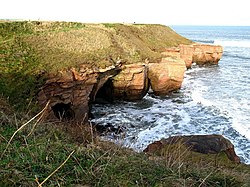
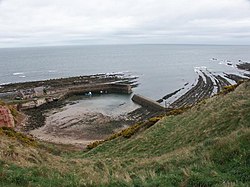
Cove, Scottish Borders
Cove is a village in the Scottish Borders area of Scotland, 18 mi (29 km) northwest of the Scotland/England border. It is about 36 miles (58 kilometres) southeast of Edinburgh and 8 mi (13 km) from Dunbar. Cove is close to Cockburnspath, Dunglass, Innerwick, Oldhamstocks, Bilsdean, and, further afield, Dunbar and Eyemouth. The climate is typical for Scotland, with cold, wet winters and variable summer weather, with days of rain and days of temperatures over 20 °C (68 °F).
The nearest railway station is Dunbar, which is on the main East Coast line from London Kings Cross to Edinburgh. There are regular trains both from Dunbar to Edinburgh and southwards to Berwick-upon-Tweed. The nearest bus station is in Cockburnspath which takes passengers north to Edinburgh terminating at St Andrews Square, and southwards, terminating in Berwick.
The rocks that form the approach to the harbour are limestones and sandstones of Carboniferous age. They dip sharply to the N/NW due to the downthrust of the Cove fault about 1⁄2 mi (800 m) southeast. Beyond the fault, older strata of the Old Red Sandstone of Devonian age can be seen.
The natural harbour was improved in 1831 by the building of a breakwater. Access is via a 100 metre tunnel that runs theough the roack. As of Summer 2024 funding is being raised for repairs to the breakwater, which has suffered storm damage on one end.
Eleven men from Cove died in the great Eyemouth disaster of 1881. There is a memorial at the top of the cliffs.
The village has been described by The AA Guide to the British Coast as having more of a Cornish than Scottish air about it. It has no school, shops or post office. There is a shop and post office nearby in the village of Cockburnspath which also has a school. For amenities, such as a pool or a gym, people need to travel to Dunbar, which is also has an ASDA supermarket.
The nearby beaches of Pease Bay (1.4 mi or 2.3 km) and Thorntonloch (3 mi or 5 km) are used for surfing.
Cove is privately owned by the architect Ben Tindall and the Cove Harbour Conservation Ltd.
The Southern Upland Way passes through Cove along the headland and the road in Cove. The John Muir Way passes through Dunbar, about 8 mi (13 km) away.
1.7 km
Berwickshire Coastal Path
The Berwickshire Coastal Path is a walking route some 48 kilometres (30 mi) long. It follows the eastern coastline of Scotland from Cockburnspath in the Scottish Borders to Berwick upon Tweed, just over the border in England. At Cockburnspath the path links with the Southern Upland Way and the John Muir Way.
The coastline traversed by the path is nationally and internationally important for seabirds, coastal flora and marine life: much of the coastline is protected as a Special Protection Area, and there is a national nature reserve at St Abbs Head which is owned by the National Trust for Scotland. Strong walkers can walk the route in two days, although the walk can be split into shorter sections to allow more time to explore the towns and villages along the way.
The path was developed by Scottish Borders Council, and is now designated as one of Scotland's Great Trails by NatureScot. The route is waymarked, and there are four memorial statues at Eyemouth, Burnmouth, St Abbs and Cove to commemorate the 189 lives lost in the Eyemouth disaster of 14 October 1881, when a hurricane devastated the fishing fleet. Twelve bronze trail markers have also been erected along the route, linking the memorial sculptures.
It connects with the Northumberland Coast Path and hence the England Coast Path at Berwick on Tweed.
1.7 km
Cockburnspath
Cockburnspath ( KOH-bərnz-path) is a village in Berwickshire in the Scottish Borders. It lies near the North Sea coast between Berwick-upon-Tweed and Dunbar. Cockburnspath is the eastern terminus of the Southern Upland Way as well as the northern terminus of the Berwickshire Coastal Path. At the nearby village of Cove, there is a small fishing harbour.