
 English
 Français

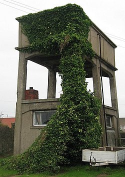
Phares de Fish Quay Old
Les phares de Fish Quay Old, (connus en anglais sous les noms de Fish Quay Old Low Light et Fish Quay Old High Light), sont deux anciens phares de port situés à North Shields Fish Quay, au nord de l'entrée de la rivière Tyne à North Shields dans le comté du Tyne and Wear en Angleterre. Érigés au XVIe siècle par la Guilde de la Sainte Trinité de Newcastle-upon-Tyne ils servaient pour l'alignement de la navigation dans l'embouchure pour éviter les dangereux écueils de Shields Bar et Black Middens (en). Ils sont maintenant protégés en tant que monument classé du Royaume-Uni de Grade II.
Nearby Places View Menu

14 m
Clifford's Fort
Clifford's Fort was a defensive gun battery established near the mouth of the Tyne during the Anglo-Dutch Wars in the 17th century. It subsequently served as a submarine mining depot and survives today as a scheduled monument in the historic Fish Quay area of North Shields, Tyne and Wear, in North East England.

76 m
Tynemouth Lifeboat Station
Tynemouth Lifeboat Station is located overlooking the River Tyne at Fish Quay, North Shields, in the county of Tyne and Wear.
A lifeboat was first stationed across the River Tyne in South Shields in 1789, with a second lifeboat placed in North Shields in 1798, both operated by the Tyne Lifeboat Institution (TLI).
The Royal National Lifeboat Institution (RNLI) currently operates a Severn-class lifeboat 17-34 Osier (ON 1263), on station since 2021, and a D-class (IB1) Inshore lifeboat Little Susie (D-829), on station since 2018.

83 m
North Shields Fish Quay
North Shields Fish Quay is a fishing port located close to the mouth of the River Tyne, in North Shields, Tyne and Wear, North East England, 8 miles (13 km) east of the city of Newcastle upon Tyne.
The quay was established in 1225 as shielings village (seasonal huts used by hunters or fishermen) around the Pow Burn; the town of North Shields, where it takes its name from the shielings. The quay was originally located to serve the nearby Tynemouth Castle and Priory. The original site is largely derelict industrial land currently being redeveloped, which belonged to the original Tyne Brand canning company. The Pow Burn runs from nearby Northumberland Park and disappears underground at Tynemouth Road and the Metro urban transport line, eventually flowing into the Tyne.
The development of North Shields was restricted due to the neighbouring port, Newcastle upon Tyne, which was the region's leading port at the time. Its trade guilds resented trade outside of the city, so that coal mined in North Shields within 300 ft (91.4 m) of the river had to be transported on land 8 miles to Newcastle to be loaded onto boats.
In the 18th and 19th centuries, the North Shields Fish Quay High Light and Low Light lighthouses, which now are defunct, provided a line of sight for vessels entering from the river mouth. Before the north and south piers were built, many ships foundered on the rocks known as the Black Middens, which lie to the east of the quay and can be seen at low tide.
The site has an original Old High Light and Old Low Light as well as High Light and Low Light, called so because they were positioned low (at river level on the quay) and high (on the bank top some 150 ft higher (46 m)).
The present quay was built in 1870 to accommodate the increase in fishing boats after the introduction of steam trawlers. It is the largest English port for prawns. Its proximity to the Dogger Bank has led fishing boats from Whitby and elsewhere on the north east coast to relocate there. Adjacent shops include fish outlets and fish processing facilities, mainly of crab and prawn.
The Fish Quay was once the biggest kipper producer in the UK, but the fall in herring stocks has reduced the trade to a single smokery. A number of traditional smokehouses still exist but have been converted to other uses, the area having been substantially repurposed to include residential accommodation, eateries and other entertainment facilities. However, although much reduced, a healthy seafood trade still exists with daily refrigerated lorry movements.
Clifford's Fort, located on the Fish Quay, was built in 1672 as a coastal defence against the Dutch, and also played a role during the Napoleonic Wars. The fort was named after Lord Clifford, a member of King Charles II's Cabal. It is now a scheduled monument.
The Fish Quay declined in the 1980s as a result of problems in the fishing industry. Refurbishment of the area was begun by Tyne and Wear Development Corporation and then beginning in 2001 based on a consultancy report. The Old Low Light building has been converted into a heritage centre, which opened in 2015.
667 m
Tyne Turrets
The Tyne Turrets were two 12-inch Mk VIII guns from the battleship HMS Illustrious, installed in Roberts Battery at Hartley, near Seaton Sluice north of the Tyne, and Kitchener Battery in Marsden near Lizard Point south of the river. The batteries were planned in World War I but only commissioned in 1921, and after a change of heart scrapped in 1926. This very heavy armament was only rivalled by the Dover harbour Admiralty Pier Turret at the time.
671 m
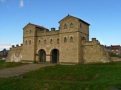
Arbeia
Arbeia was a large Roman fort in South Shields, Tyne & Wear, England, now ruined, and which has been partially reconstructed. It was first excavated in the 1870s. All modern buildings on the site were cleared in the 1970s. It is managed by North East Museums as Arbeia, South Shields Roman Fort.