
 English
 Français

Onesacre Hall
Onesacre Hall is a Grade II* Listed building situated in the rural outskirts of the City of Sheffield in South Yorkshire, England. The hall is located on Green Lane in the small hamlet of Onesacre in the suburb of Oughtibridge, 5 miles (8.5 km) north west of the city centre.
Nearby Places View Menu

916 m
Glen Howe Park
Glen Howe Park is a public recreation area in the village of Wharncliffe Side within the City of Sheffield, England. The park covers an area of 19 acres in the valley of the Tinker Brook, a minor tributary of the River Don. It is home to a variety of fungi, rare plants and animals only found in ancient woodlands.
992 m
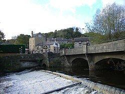
Oughtibridge
Oughtibridge ( OOT-i-brij) is a residential village in the north of Sheffield within the bounds of Bradfield civil parish. The village stands about 5 miles (8 km) northwest of the city centre in the valley of the River Don.
The population of the village has increased significantly in recent years because of much private housing development and stood at 3,542 in 2006 over an area of 355 hectares (880 acres). The population of Oughtibridge increased to 3,584 in 2011.

1.5 km
Oughty Bridge railway station
Oughty Bridge railway station was a railway station on the Sheffield, Ashton-under-Lyne and Manchester Railway built to serve the village of Oughtibridge, Sheffield, South Yorkshire, England.
The station, which lies between Wadsley Bridge and Deepcar was opened on 14 July 1845 and closed on 15 June 1959. The old station house is a grade two listed building constructed from gritstone and has been used for industrial purposes for a number of years. In 2008 it was renovated and converted into a house. When the station was still in use, the goods sidings were used for carrying wood pulp to the nearby paper mill and also freight to and from the Oughtibridge silica works.

1.5 km
Wharncliffe Side
Wharncliffe Side is a village in South Yorkshire, England, northwest of Sheffield and within the city borough.
Wharcliffe Side is located on the west bank of the River Don, approximately six miles (9.7 km) northwest of Sheffield city centre, and one mile (1.6 km) northwest of Oughtibridge, south of the confluence of the Ewden beck and the River Don. The village is at an elevation of 435 feet (133 m) and the A6102 road passes through the village.
The village has a population of 1355 as of 2011, and is a commuter village for Sheffield and Stocksbridge. The village is within the Stocksbridge and Upper Don electoral ward. There is a primary school on Brighthomelee Lane, along with a post office and two public houses within the village. Glen Howe Park is situated at the southern end of the village. The ancient farming hamlet of Brightholmlee lies 1⁄2 mile (0.80 km) to the west.