
 English
 Français

Dishforth
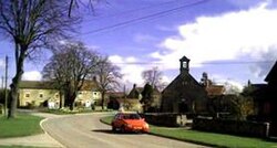
Dishforth is a village and civil parish in the county of North Yorkshire, England. Dishforth translates from Old English as dic-ford; a ford by a dike or ditch. The population of the parish taken at the 2001 census as 719 and had risen to 905 by the time of the 2011 census. From 1974 to 2023 it was part of the Borough of Harrogate, it is now administered by the unitary North Yorkshire Council. It is just north of Dishforth Airfield, which up until April 2016 was an Army Air Corps helicopter station.
Nearby Places View Menu

115 m
Dishforth Village Hall
Dishforth Village Hall is a historic building in Dishforth, a village in North Yorkshire, in England.
Dishforth had a church in the mediaeval period, but it was entirely rebuilt in 1791, as a rectangular building, with a west porch, and an east gallery. From 1884 to 1885, it was restored and extended by James Mallinson. The church was grade II listed in 1987. The church closed in about 2006, and was converted into a new village hall, replacing a wooden structure. The work was undertaken by Dishforth Parish Council, and included a new roof and floor, kitchen and toilets.
The church is built of sandstone, with stone slates on the body of the church, and grey slate on the apse. It consists of a three-bay nave, a west porch, a north aisle, and a polygonal apse. The porch is gabled, and contains a doorway with a pointed arch, above which are two oculi, and a gabled bellcote. Enclosing the forecourt on the west and south sides is a low wall with pointed coping and a wrought iron railing. At the entrance are gates, and an overthrow with scroll decoration and a lantern bracket.

1.7 km
RAF Dishforth
Royal Air Force Dishforth or more simply RAF Dishforth is a former Royal Air Force station near Thirsk in North Yorkshire, England. Opened in 1936, the base was used as a bomber airfield during the Second World War with both British and Canadian squadrons flying missions from the airfield. After the war, the base was used by various squadrons and training units before being disposed of in 1992 and handed over to the Army Air Corps.
1.8 km
Dishforth Airfield
Dishforth Airfield (ICAO: EGXD) is a former Royal Air Force and current British Army station in North Yorkshire, England. It was previously an Army Air Corps helicopter base and a Relief Landing Ground for RAF Linton-on-Ouse. 6 Regiment RLC is currently located at Dishforth.
It is located next to the A1(M) at Junction 49 with the A168. Dishforth airfield is built over part of the Great North Road which is also the old A1. It is 4.4 miles (7.1 km) east of Ripon, North Yorkshire and 11.5 miles (18.5 km) north east of Harrogate, North Yorkshire, England.
2.3 km
Rainton
Rainton is a village in the county of North Yorkshire, England. It is situated about 6 miles (9.7 km) north of Boroughbridge, 5 miles (8 km) north-east of Ripon and 5 miles (8 km) south-west of Thirsk. The area has a village green and a maypole. There are approximately 120 houses in Rainton including six listed buildings, several period farm houses, a smithy and a dovecote. The local vernacular building style is sandstone and cobble construction with slate or pantile roof.