
 English
 Français

Dewartown
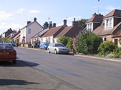
Dewartown is a small hamlet in Midlothian, Scotland (near Pathhead and Mayfield). Its name relates to the Dewar family who owned the nearby Vogrie House and Estate which is now in Vogrie Country Park. The village is reputed to have had five public houses during the 19th century, providing for the many farm workers, miners and house staff from the local community. Dewartown is still not listed on many maps, despite the fact a number of the cottages date back to the early 18th century. Signs erected in the late 1990s depicted the village as 'Dewarton', rather than 'Dewartown'. These were replaced with the latter spelling, despite the fact both spellings are competent, the former being a regional contraction, vis 'ton' meaning 'town'.
Nearby Places View Menu

896 m
Vogrie Country Park
Vogrie Country Park in Scotland is managed by Midlothian Council. It consists of a woodland estate surrounding the Victorian Vogrie House.
It is located around 12 miles (19 km) from Edinburgh between Pathhead and Gorebridge.
Facilities in the parkland include a miniature railway, 9-hole golf course, children's play area and four miles of walks.
The park is the home to Vogrie Pogrie Festival, held annually mid September since 2021.
The River Tyne flows through the park.

916 m
Vogrie House
Vogrie House forms the centrepiece of Vogrie Country Park in Midlothian.
It was built for James Dewar and his family in 1876 by Andrew Heiton, the town architect for Perth. Dewar was the creator of Dewar's whisky.
The current house is an example of Victorian baronial splendour and is said to be one of the best surviving examples of Heiton's work. The house was a typical country house with a library, servants' quarters and many bedrooms.
Transformed in 1926 into a nursing home for the Royal Edinburgh Hospital, by Ernest Auldjo Jamieson the house was sold on to local government in the 1950s and had a role during the Cold War as a control centre for communications.
The park surrounding Vogrie House hosts Vogrie Pogrie Festival, held annually mid September since 2021.
991 m

1.6 km
Cranston, Midlothian
Cranston is a parish of Midlothian, Scotland, lying 4+1⁄4 miles (6.8 kilometres) south-east of Dalkeith. It is bounded by the parishes of Inveresk and Ormiston (East Lothian) on the east, by Crichton and Borthwick on the south; and by Newbattle on the west and north. The River Tyne flows through the centre of the parish.
The parish is in the northern part of the Tynewater Community Council area and includes the villages of Edgehead, Pathhead, Midlothian and Ford, and the mansions of Oxenfoord Castle and Preston Hall. In a northern salient of the parish, almost detached from the rest, lies the village of Cousland. The chapelry of Cousland was annexed to Cranston about the time of the Reformation.
In the 12th century Cranston was divided into two baronies, Upper Cranston and Nether Cranston, which were later known as New Cranston and Cranston Ridel, respectively. The church stands at Nether Cranston, which was the larger of the two baronies. This district was granted to Hugh Ridel from whom it obtained the name.
The parish church was built at the expense of General Sir John Dalrymple, of Oxenfoord, replacing the previous church which was in the old burial grounds south of Oxenfoord Castle's gardens. The old church had been damaged by fire in 1796 and rebuilt in 1798, but was finally replaced by the new building in 1824. The present church was damaged by fire in 1861, but was quickly repaired and enlarged. The manse, which was re-sited from beside the Lion's Gate of Prestonhall House in 1835, has now been sold as a private house.
A Parochial Board was established under the Poor Law (Scotland) Act 1845. With the Local Government (Scotland) Act 1894 the Parish Council was established, which continued until 1930 when parish councils in Scotland were abolished. Civil parishes persist for census and other non-administrative purposes.
The civil parish has a population of 601 (in 2011).