
 English
 Français

Derwent Edge
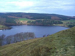
Derwent Edge is a Millstone Grit escarpment that lies above the Upper Derwent Valley in the Peak District National Park in the English county of Derbyshire. An Ordnance Survey column marks the highest point of the Edge at Back Tor (538 metres, 1765 feet). North of Back Tor the edge extends into Howden Edge and enters the county of South Yorkshire.
Nearby Places View Menu

1.9 km
Lost Lad
Lost Lad is a hill, 518 metres (1,699 ft) high on the Derwent Edge in the Peak District in the county of Derbyshire in England. It is a subpeak of Back Tor (538 metres [1,765 ft]).

2.7 km
Crook Hill
Crook Hill is a small hill in the Peak District National Park in the English county of Derbyshire, 5 kilometres (3.1 mi) north east of Castleton.
3.6 km
Strines Reservoir
Strines Reservoir is a water storage reservoir situated at 53.4099°N 1.6557°W / 53.4099; -1.6557 (Strines_Reservoir), 8 miles (13 km) west of the centre of Sheffield in South Yorkshire, England.

3.6 km
Sugworth Hall
Sugworth Hall is an English country house on Sugworth Road in Bradfield Dale, near Sheffield, England. It is situated approximately 8 miles (13 km) west from Sheffield City Centre. The hall is a Grade II listed building which stands within the Peak District National Park at a height of 984 feet (300 m) above sea level.