
 English
 Français

Easter Howgate
Easter Howgate is a settlement in Midlothian, Scotland, UK, on the A702, two miles north of Penicuik. The Scottish Agricultural College maintains a teaching campus and a research farm there, named "Edinburgh Genetics".
Nearby Places View Menu

910 m
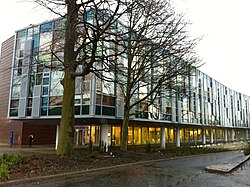
Royal (Dick) School of Veterinary Studies
The Royal (Dick) School of Veterinary Studies (abbreviated as the Dick Vet) is the veterinary school within the College of Medicine and Veterinary Medicine at the University of Edinburgh in Scotland.
The School was ranked first in the UK in the ShanghaiRanking's Global Ranking of Academic Subjects 2022 – Veterinary Sciences, second in the UK by the QS World University Rankings 2023 for Veterinary Science, first in the UK for the sixth year running by the Guardian League Table 2022, and second in the UK for the second year running by the Times and Sunday Times Good University Guide ranking for Veterinary Medicine.
1.0 km
Roslin Institute
The Roslin Institute is an animal sciences research institute at Easter Bush, Midlothian, Scotland, part of the University of Edinburgh, and is funded by the Biotechnology and Biological Sciences Research Council.
It is best known for creating Dolly the sheep in 1996, the first mammal to be successfully cloned from an adult cell.

1.2 km
Castle Law
Castle Law is a hill south west of Fairmilehead in the Pentland Hills in Midlothian, Scotland.
It is best known for the Iron Age hill fort on its slopes.
1.5 km
Glencorse
Glencorse is a parish of Midlothian, Scotland, lying 7 miles (11 kilometres) south of Edinburgh. It is bounded on the north-west by the former parish of Colinton now within the City of Edinburgh, to the north and west by Lasswade and to the south and west by Penicuik.
The parish is in the northern part of the Penicuik and District Community Council area and includes the village of Auchendinny near its eastern boundary.
The parish is traversed from west to east by Glencorse Burn, part of whose valley contains Glencorse Reservoir, which was formed in 1819–28 by damming the burn's glen with a huge embankment 40 m (130 ft) high. The reservoir is a source of Edinburgh's water supply. Also in the parish are Glencorse Barracks, Bush House, Glencorse House, Woodhouselee and Easter Howgate. The northern part of the parish includes some of the Pentland Hills and the highest point within the parish is Turnhouse Hill (428 m or 1,403 ft).
Historical records of the parish before 1878 spell it in various different ways - Glencors, Glencrosss, Glencrosse and Glencorse. After 1878 the last was normally used. There are several theories about the origin of the name Glencorse. One is that it comes form the Gaelic gleann - a glen and grosg or craig, a crossing - so a glen crossing the Pentland hills. George Chalmers in his book "Caledonia" claims the name comes from "a very remarkable cross, which has been erected in the vale of Glencross by pious hands." Yet another theory is that the name comes from a miraculous cross that appeared above Carnethy hill and encouraged the Scottish soldiers to defeat the English forces at the Battle of Roslin in 1303.
The parish is divided between two Scottish Parliamentary constituencies: Midlothian North and Musselburgh to the north of Glencorse burn and Midlothian South, Tweeddale and Lauderdale south of the burn.