
 English
 Français

Cliburn, Cumbria
Cliburn is a village and civil parish in the Westmorland and Furness Unitary Authority of Cumbria, England; the civil parish includes the hamlet of Town Head. At the 2001 census, the population was 204; this increased to 274 by 2011.
Nearby Places View Menu

1.2 km
Cliburn railway station
Cliburn railway station was a stop on the Eden Valley Railway in Westmorland (now in Cumbria), England; it is located to the north of the village of Cliburn.

1.3 km
River Leith
The River Leith is a watercourse in Cumbria, a county of northwestern England.
Rising at Shap, the Leith flows north alongside the M6 motorway via Great and Little Strickland before turning eastward at Melkinthorpe. Having passed through Cliburn, the Leith flows into the River Lyvennet at Cliburn Mill.
1.4 km
Cliburn Moss
Cliburn Moss is a national nature reserve located northwest of the village of Cliburn, in the county of Cumbria, England (NY577256). It contains wetland habitats, produced by a hollow in the glacial valley. It is designated as a Site of Special Scientific Interest.
The 26 ha site was designated as a national nature reserve in 1996. Prior to becoming a protected area, it was affected by the human activities of peat cutting and drainage. The reserve is managed with the aims of restoring areas of fen, heath and mire and controlling the spread of trees.
1.9 km
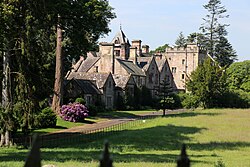
Crossrigg Hall
Crossrigg Hall is a country house in the civil parish of Bolton, Cumbria in the northern United Kingdom. It was built in 1864 by Lieutenant Colonel Hugh Rigg of the Indian Army's Madras Infantry. Designed by Anthony Salvin, and with later additions by J. H. Martindale, the hall is a Grade II* listed building.