
 English
 Français

Battle of Stirling (1648)
The second Battle of Stirling was fought on 12 September 1648 during the Scottish Civil War of the 17th century. The battle was fought between the Engagers who were a faction of the Scottish Covenanters under the command of George Munro, 1st of Newmore and who had made "The Engagement" with Charles I of England in December 1647, against the Kirk Party who were a radical Presbyterian faction of the Scottish Covenanters who were under the command of Archibald Campbell, 1st Marquess of Argyll.
Nearby Places View Menu
0 m
Stirling Sill
The Stirling Sill is an outcropping of a large quartz-dolerite intrusion or sill that underlies a large part of central Scotland, and may be contiguous at great depth. The sill is of very late Carboniferous age or more probably Permian, as it penetrates the coal measures, often in bedding planes between the various strata. In places, it rises through fractures in the strata to a new level, forming features that, at the surface, would be called dikes.
At its outcrop on the west, the sill generally lies towards the base of the Carboniferous sequence, and just above the calciferous sandstone deposits and lavas, as can be seen in the upper part of the valley of the Bannock Burn. However, to the consternation of miners, it occupies a higher position amongst the useful strata towards the east, and in places has destroyed the coal, while in others the effect of the sill has been to convert the coal to more valuable anthracite.
The slope of the Abbey Craig, or the Stirling Castle rock, gives a general idea of the angle of dip of the coal measures at the extremity or the coalfield, and the thickness of the sill can also be seen, which is approximately 100 metres.
Geologists have had various theories about the formation of anthracite, as the coal has been most effectively baked near the Ochil Fault, however the theories are not necessarily incompatible.
The source of the sill, where the molten rock rose from below, is not known; however it is known that there are risers in the Ochil Fault, although these are inconsistent with the overall structure. The main origin of the sill may be in the region of the eruptive centre that formed the Ochil Hills in a much earlier period, which geologists postulate is somewhere to the east of Stirling, possibly in the region of Kincardine. This ties in with subsidence following the first round of eruptive activity that lead to the formation of the coal basins, with a much later outbreak of intrusive activity from the same magma feeders, however the truth will remain unknown because it would take very many deep bores in hard rock to probe the depths and find the necessary evidence.
The western extremities of the sill can be seen at the Abbey Craig, Stirling Castle, Kings Park, Gillies Hill, Sauchieburn and various points to the south.
The quartz-dolerite was once quarried at several places including Cambusbarron and Murrayshall, but is quarried today at Northfield, primarily for roadstone.
21 m
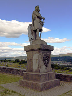
Statue of Robert the Bruce, Stirling Castle
The statue of Robert the Bruce on the esplanade at Stirling Castle, Stirling, is a 1876 work sculpted by Andrew Currie and designed by illustrator George Cruikshank. As of 2020, the statue is featured on the Clydesdale Bank £20 note.
148 m
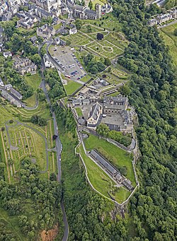
Stirling Castle
Stirling Castle, located in Stirling, is one of the largest and most historically and architecturally important castles in Scotland. The castle sits atop an intrusive crag, which forms part of the Stirling Sill geological formation. It is surrounded on three sides by steep cliffs, giving it a strong defensive position. Its strategic location, guarding what was, until the 1890s, the farthest downstream crossing of the River Forth, has made it an important fortification in the region from the earliest times.
Most of the principal buildings of the castle date from the fifteenth and sixteenth centuries. A few structures remain from the fourteenth century, while the outer defences fronting the town date from the early eighteenth century.
Before the union with England, Stirling Castle was also one of the most used of the many Scottish royal residences, very much a palace as well as a fortress. Several Scottish Kings and Queens have been crowned at Stirling, including Mary, Queen of Scots, in 1542, and others were born or died there.
There have been at least eight sieges of Stirling Castle, including several during the Wars of Scottish Independence, with the last being in 1746, when Bonnie Prince Charlie unsuccessfully tried to take the castle. Stirling Castle is a Scheduled Ancient Monument, and is now a tourist attraction managed by Historic Environment Scotland.

195 m
Argyll's Lodging
Argyll's Lodging is a 17th-century town-house in the Renaissance style, situated below Stirling Castle in Stirling, Scotland. It was a residence of William Alexander, 1st Earl of Stirling and later the Earls of Argyll. The Royal Commission regards it as “the most important surviving town-house of its period in Scotland”. At the end of the 20th century it became a museum.