
 English
 Français

Bothel, Cumbria
Bothel is a small village in Cumbria, England. Bothel was historically within Cumberland.
Nearby Places View Menu

642 m
Bothel and Threapland
Bothel and Threapland is a civil parish in Cumbria, England, just outside the Lake District National Park. According to the 2001 census, it had a population of 438. The parish includes the villages of Bothel and Threapland. The village of Bothel is south-east of the parish of Aspatria and Threapland is south of Aspatria and Carlisle is eighteen miles (29 km) North-east of the parish. It had a population of 483 in the 2011 census figures.

1.2 km
Caer Mote
Caer Mote is a hill of 289 metres (948 ft) in the north of the English Lake District near Bothel, Cumbria. Its summit lies just outside the boundary of the Lake District National Park and offers a view of Bassenthwaite Lake. Under the name Caermote Hill it is the subject of a chapter of Wainwright's book The Outlying Fells of Lakeland. Wainwright's route is an ascent from Bothel to the northern summit St. John's Hill at 285 metres (935 ft), continuing south to the main summit and south east to meet a minor road beside the Roman fort and follow that road north for an anticlockwise circuit. In his original book Wainwright lists the height as 920 feet (280 m), but in the 2011 2nd edition Chris Jesty corrects this to 948 feet.
There is an ancient earthwork enclosure of undetermined age, known as "The Battery" on the northern summit, St. John's Hill. There are traces of a 1st-century AD Roman fort below the hill, to the south east.
Caermote Hill is listed by the Database of British and Irish Hills as a TuMP, and St John's Hill is given the subtitle "Caermote Hill N Top"; both summits are recognised as "Wainwright Outlying Fells".
2.0 km
Blennerhasset and Torpenhow
Blennerhasset and Torpenhow is a civil parish in Cumbria, England. According to the 2001 census it had a population of 437, reducing to 423 at the 2011 Census. It includes the villages of Blennerhasset grid reference NY178415 and Torpenhow at NY202397 and the smaller settlement of Kirkland Guards at NY187401. It is located just outside the Lake District National Park. Baggrow railway station was immediately north of Blennerhasset.
The local pronunciation of Torpenhow is trə-PEN-ə ( ), rather than the more intuitive TOR-pən-how (). Blennerhasset is pronounced blen-RAY-sit () instead of BLEN-ər-hass-it () as would be expected outside of Cumbria.
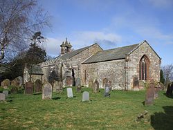
St Michael's Church, Torpenhow has a Norman chancel arch with a remarkable carving of interlocking human figures, and a painted wooden ceiling.

2.4 km
Baggrow
Baggrow is a small village situated north of the Lake District National Park in the English county of Cumbria, historically within Cumberland.
In many parts of the village views of England's 4th highest peak Skiddaw, standing 931 metres (3053 ft) above sea level, can be seen to the south east, some 9.5 mi (15 km) away.