
 English
 Français

High Crag (Helvellyn)
High Crag is a minor fell on the Helvellyn Range in the eastern region of the English Lake District. It sits on the ridge to the south of Helvellyn and Nethermost Pike. It rises sharply above the head of Ruthwaite Cove, and has attracted the attention of rock climbers. Its rock type is a lapilli tuff of the Helvellyn Tuff Formation.
Nearby Places View Menu

538 m
Nethermost Pike
Nethermost Pike is a fell in Cumbria, England, and a part of the Lake District. At 891 metres (2,923 ft) it is the second highest Wainwright in the Helvellyn range, the highest of which is Helvellyn itself. It is located close to the southern end of the ridge, with Helvellyn to the north, and High Crag and Dollywaggon Pike to the south. Nethermost Pike, along with many of the Eastern Fells, lies between Thirlmere in the west and the Ullswater catchment in the east. The closest villages are Glenridding and Patterdale on the shores of Ullswater, over 8 kilometres (5 mi) away.
Like most fells in the Helvellyn range, Nethermost Pike has grassy western slopes and rocky outcrops on the eastern side. Geologically, Nethermost Pike belongs to the Borrowdale Volcanic Group. Lead was once mined on its eastern slopes, resulting in open workings and underground mines. The eastern slopes are protected as part of a Site of Special Scientific Interest because of the Pike's geological and biological features, which include some of England's best arctic-alpine and tall-herb vegetation.

714 m
Dollywaggon Pike
Dollywaggon Pike is a fell in the English Lake District. It stands on the main spine of the Helvellyn range in the Eastern Fells, between Thirlmere and the Ullswater catchment.

1.5 km
Helvellyn
Helvellyn (; possible meaning: pale yellow moorland) is a mountain in the English Lake District, the highest point of the Helvellyn range, a north–south line of mountains to the north of Ambleside, between the lakes of Thirlmere and Ullswater.
Helvellyn is the third-highest point both in England and in the Lake District, and access to Helvellyn is easier than to the two higher peaks of Scafell Pike and Scafell. The scenery includes three deep glacial coves and two sharp-topped ridges on the eastern side (Striding Edge and Swirral Edge). Helvellyn was one of the earliest fells to prove popular with walkers and explorers; beginning especially in the later 18th century. Among the early visitors to Helvellyn were the poets Samuel Taylor Coleridge and William Wordsworth, both of whom lived nearby at one period. Routes up the mountain permit approach from many directions.
However, traversing the mountain is not without dangers; over the last two hundred years there have been a number of fatalities. The artist Charles Gough is more famous for his death on Striding Edge in 1805 than for what he achieved in his life. Among the human feats upon the mountain, one of the strangest was the landing and take-off of a small aeroplane on the summit in 1926.
Since 2020, the summit of Helvellyn including both Striding and Swirral Edges and the wider Glenridding Common have been managed by the John Muir Trust, a wild places conservation charity in partnership with the Lake District Park Authority.
1.6 km
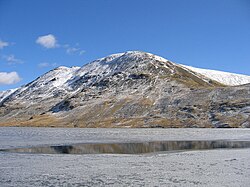
Grisedale Tarn
Grisedale Tarn is a tarn in the Lake District of England between Fairfield and Dollywagon Pike.
It is the legendary resting place of the crown of the kingdom of Cumbria, after the crown was conveyed there in 945 by soldiers of the last king, Dunmail, after he was slain in battle with the combined forces of the English and Scottish kings.
Grisedale Tarn is 538 metres (1,765 ft) in altitude and has a maximum depth of around 33 metres (108 ft). It holds brown trout, perch and eels. The outflow is to Ullswater to the north-east, picking up all of the rainfall from the eastern face of Dollywagon Pike.
The Tarn is the subject of a poem by the Rev. Frederick William Faber printed in 1840.