
 English
 Français
Alloa Junction railway station
Alloa Junction railway station was located near Plean, Stirling, Scotland, from 1850 to 1865.
Nearby Places View Menu

841 m
Stirling and Falkirk
Stirling and Falkirk is a lieutenancy area of Scotland. It consists of the local government areas of Stirling and Falkirk,
which cover the same areas as the previous districts from 1975 to 1996.

936 m
Plean Castle
Plean Tower, also known as Cock-a-bendy Castle, Mengie Castle, Menzies Castle and Plane Castle, is located around 1 mile (1.6 km) from Plean, in Stirling, central Scotland. It comprises a small oblong tower house probably dating from the 15th century, and an adjoining 16th-century manor house.
1.6 km
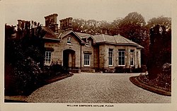
William Simpson's Home
The William Simpson's Home is a care home in Plean, Scotland. It provides care for members of the armed services who have developed mental health or alcohol related problems.

1.7 km
Torwood
Torwood (Scottish Gaelic: Coille Tor) is a small village located 2 miles (3.2 km) north-northwest of Larbert, 4 miles (6.4 km) north-west of Falkirk and 6 miles (9.7 km) south-southeast of Stirling. Torwood lies within the Falkirk Council area of Scotland. The population recorded in the 2011 UK Census was 245.
The A9 road between Bannockburn and Camelon runs through the village. Torwood Has 5 streets: Provost Gardens, Stirling Road, Castle Crescent, Forester Gait & Glen Road. Glen Road leads on to Torwood Castle, Quarry and Broch.