


Rancho Santa Maria de Los Peñasquitos was a 8,486-acre (34.34 km2) Mexican land grant in present-day southwestern San Diego County, California, given in 1823 to Francisco María Ruiz. The name means "Saint Mary of the Little Cliffs". It encompassed the present-day communities of Mira Mesa, Carmel Valley, and Rancho Peñasquitos in northern San Diego, and was inland from the Torrey Pines State Natural Preserve bluffs.
Gallery

Sponsored
Location
1 explorer visited this place

1.9 km
The Los Peñasquitos Creek Arch Bridge is a pair of road bridges in San Diego, California.
Completed in 1949, the original bridge is a reinforced concrete open-spandrel arch-bridge with an overall length of 434 feet, and arch span of 220 feet. It now serves as a service road and bike path.
The new Los Peñasquitos Creek bridge was first built in 1966 as the southbound lanes of the U.S. Route 395 freeway. It was completely replaced by a prestressed concrete girder bridge during the widening of the Interstate 15 freeway in 1976.
2.6 km
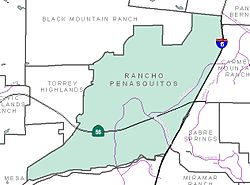
Rancho Peñasquitos is a suburban community in northeastern San Diego, California. It is named after the first Mexican land grant in San Diego County, Rancho Santa Maria de Los Peñasquitos. The community abuts Los Peñasquitos Canyon Preserve, an open space preserve that offers hiking, biking, and equestrian trails. The community is commonly abbreviated "PQ."
The population of Rancho Peñasquitos is approximately 60,000. it is located in ZIP Code 92129. The telephone area codes are 619 and 858.
3.0 km
Mira Mesa, which was established in the late 1960s, is a community and neighborhood in San Diego, California. The city-recognized Mira Mesa Community Plan Area is roughly bounded by Interstate 15 on the east, Interstate 805 on the west, the Los Peñasquitos Canyon on the north and Marine Corps Air Station Miramar on the south. Most of the community plan area is referred to as Mira Mesa; the community plan area also includes the neighborhoods of Sorrento Valley and Sorrento Mesa.
The Mira Mesa neighborhood, as defined by the San Diego Police Department's neighborhood map, is roughly bounded by Interstate 15 to the east, Camino Santa Fe to the west, the Los Peñasquitos Canyon to the north and Carroll Canyon to the south.

3.2 km
Sabre Springs is a community in San Diego, California, located in the northeastern part of the city. It is bounded by the city limits of Poway on the east, Ted Williams Parkway on the north, Interstate 15 on the west, and the community of Miramar Ranch North to the south. Sabre Springs is bisected north-south by Poway Road.
The surrounding communities are Carmel Mountain to the north, Rancho Peñasquitos to the west, and Scripps Ranch to the south.
Sabre Springs also features a business park which includes several notable businesses such as General Atomics - Aeronautical, Bridgepoint Education and Hospira.
The telephone area code is 858, and the ZIP code is 92128.

3.2 km
Mt. Carmel High School is a public high school in Rancho Peñasquitos, a community of San Diego, California, United States. It is part of Poway Unified School District. The school's mascot is the Sundevil.
Mt. Carmel High School is both a California Distinguished School Award winner and a National Blue Ribbon School. Mt. Carmel was named a California Gold Ribbon School in 2017. Mt. Carmel was named a California Honor Roll School by Educational Results Partnership for the 2017–18, 2016–17, and 2015–16 school years.
Book your tour near
Rancho Santa Maria de Los Peñasquitos
Book Now
4.2
in partnership with
GetYourGuide.com