
 English
 Français

Château de Tarbert
Le château de Tarbert est situé sur la rive sud de Tarbert Bay, à Tarbert, en Argyll, en Écosse, à l'extrémité nord de Kintyre. Le château de Tarbert est une forteresse royale stratégique au Moyen Âge et un des trois châteaux de Tarbert. Le château permet de surveiller le port et bien qu'il date d'avant le XIVe siècle, les tours datent de 1494 et de la visite de Jacques IV d'Écosse dans les Western Highlands.
Nearby Places View Menu
0 m
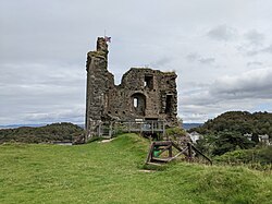
Tarbert Castle
Tarbert Castle is located on the southern shore of East Loch Tarbert, at Tarbert, Argyll, Scotland, at the north end of Kintyre. Tarbert Castle was a strategic royal stronghold during the Middle Ages and one of three castles at Tarbert. The castle overlooks the harbour and although pre 14th century in construction, the tower dates back to 1494 and the visit of James IV to the Western Highlands.

439 m
Tarbert, Kintyre
Tarbert (Scottish Gaelic: An Tairbeart, pronounced [ən̪ˠ ˈt̪ʰaɾʲapərˠʃt̪]; more fully Tairbeart Loch Fìne "Tarbert [of] Loch Fyne" to distinguish it from other Tarberts) is a village in the west of Scotland, in the Argyll and Bute council area. It is built at the head of an inlet of Loch Fyne called East Loch Tarbert, on a narrow isthmus which connects Kintyre to the south with Knapdale to the north and separates East Loch Tarbert from the much longer West Loch Tarbert which leads to the Sound of Jura and the Atlantic. Tarbert had a recorded population of 1,338 in the 2001 Census.
Tarbert has a long history both as a harbour and as a strategic point guarding access to Kintyre and the Inner Hebrides. The name Tarbert is an anglicised form of the Gaelic word tairbeart, which literally translates as "carrying across" and refers to the narrowest strip of land between two bodies of water over which goods or entire boats can be dragged or carried (portage). In past times cargoes were discharged from vessels berthed in one loch, hauled over the isthmus to the other loch, loaded onto vessels berthed there and shipped onward, allowing seafarers to avoid the sail around the Mull of Kintyre.
Tarbert was anciently part of the Gaelic overkingdom of Dál Riata and protected by three castles – in the village centre, at the head of the West Loch, and on the south side of the East Loch. The ruin of the last of these castles, Tarbert Castle, still exists and dominates Tarbert's skyline. Around the year 1098 Magnus Barefoot, King of Norway, is said to have had his longship dragged across the isthmus at Tarbert with the helmsman in place, to meet the agreed definition of an island, and establish his possession of Kintyre as one of the Western Isles.
Despite its distinction as a strategic stronghold during the Middle Ages, Tarbert's socioeconomic prosperity came during the Early Modern period, as the port developed into a fishing town. At its height, the Loch Fyne herring fishery attracted hundreds of vessels to Tarbert.

546 m
Tarbert Parish Church
Tarbert Parish Church is a Category B listed building in Tarbert, Kintyre, Argyll and Bute.

759 m
East Loch Tarbert, Argyll
East Loch Tarbert, Argyll is a small sea loch on the eastern side of the Kintyre Peninsula, in Argyll and Bute, west of Scotland. It is a part of the much larger Loch Fyne. The village of Tarbert is distributed along the shores of the loch. East Loch Tarbert is separated from West Loch Tarbert by an isthmus, that is only 1.5 kilometres (0.93 mi) long.
According to Snorri Sturluson's Heimskringla, Magnus Barefoot, King of Norway, had his longship dragged across this isthmus as part of a campaign to increase his possessions in the Hebrides. He made an arrangement with King Malcolm III of Scotland that he could take possession of land on the west coast around which a ship could sail. Magnus declared that Kintyre had "better land than the best of the Hebrides", and by taking command of his ship's tiller and "sailing" across the isthmus he was able to claim the entire peninsula, which remained under Norse rule for more than a dozen years as a result.
More than two centuries later Robert the Bruce completed a similar feat during the Scottish Wars of Independence in order to impress the clan chieftains of Argyll. He used tree trunks as rollers.
In the 18th century Thomas Pennant recorded that sea-going vessels of up to 10 tonnes (9.8 long tons) were being hauled over the isthmus in order to avoid the dangers of storms and tidal races in the seas surrounding the Mull of Kintyre. James Watt surveyed the area and decided that it was feasible to construct a canal between the two lochs. Some 60 years later it was estimated that the cost for a cut without locks would be £90,000 but delays in implementation and the construction of the Crinan canal in 1801 rendered the plan redundant.
In the modern era the Tarbert (Loch Fyne) Harbour Commissioners control the loch, an area defined as "from the point of Garvell on the North, to the Oakenhead or Rudha Loigste point on the South". There are various quays and slipways in the inner harbour and 80 pontoon berths for yachts and other leisure craft.

2.9 km
Barmore Island
Barmore Island is a peninsula in Scotland located on the east of Knapdale, in the council area of Argyll and Bute. It is 1 and a half miles north from Tarbert.
The peninsula is attached to the main land by a narrow strip.