
 English
 Français

Yester Parish Church
Yester Parish Church is a church of the Church of Scotland in the village of Gifford, East Lothian, Scotland. The village forms part of Yester, Bolton and Saltoun parish, and is a linked charge with Humbie Parish Church.
Nearby Places View Menu

94 m
Gifford, East Lothian
Gifford is a village in the parish of Yester in East Lothian, Scotland. It lies approximately 4 miles (6.4 km) south of Haddington and 25 miles (40 km) east of Edinburgh.
It groups around the Colstoun Water (locally called Gifford Water) at the junction of the B6369 and B6355 surrounded by rural farmland.
142 m
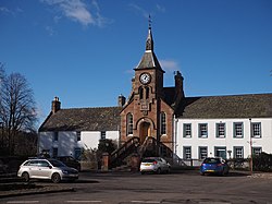
Gifford Town Hall
Gifford Town Hall is a municipal building in The Square, Gifford, East Lothian, Scotland. The structure, which is used as a community events venue, is a Category B listed building.

550 m
Gifford railway station
Gifford railway station served the village of Gifford, East Lothian, Scotland, from 1901 to 1933 on the Macmerry Branch.
1.5 km
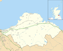
East Lothian
East Lothian (; Scots: Aest Lowden; Scottish Gaelic: Lodainn an Ear) is one of the 32 council areas of Scotland, as well as a historic county, registration county and lieutenancy area. The county was called Haddingtonshire until 1921.
In 1975, the historic county was incorporated for local government purposes into Lothian Region as East Lothian District, with some slight alterations of its boundaries. The Local Government etc. (Scotland) Act 1994 later created East Lothian as one of 32 modern council areas. East Lothian lies south of the Firth of Forth in the eastern central Lowlands of Scotland. It borders Edinburgh to the west, Midlothian to the south-west and the Scottish Borders to the south. Its administrative centre and former county town is Haddington while the largest town is Musselburgh.
Haddingtonshire has ancient origins and is named in a charter of 1139 as Hadintunschira and in another of 1141 as Hadintunshire. Three of the county's towns were designated as royal burghs: Haddington, Dunbar, and North Berwick.
As with the rest of Lothian, it formed part of the Anglo-Saxon kingdom of Bernicia and later the Kingdom of Northumbria. Popular legend suggests that it was at a battle between the Picts and Angles in the East Lothian village of Athelstaneford in 823 that the flag of Scotland was conceived. From the 10th century, Lothian transferred from the Kingdom of England to the authority of the monarchs of Scotland. It was a cross-point in battles between England and Scotland and later the site of a significant Jacobite victory against Government forces in the Battle of Prestonpans. In the 19th century, the county is mentioned in the Gazetteer for Scotland as chiefly agricultural, with farming, fishing and coal-mining forming significant parts of the local economy.