


The Turn Store and the Tinsmith's Shop, also known as Turn's Bushkill General Store, are two historic commercial buildings that are located in the Delaware Water Gap National Recreation Area at Lehman Township, Pike County, Pennsylvania. It was added to the National Register of Historic Places in 1978.
Location
142 m
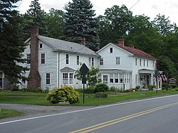
Peters House, also known as the Corner House Antique Store, is a historic home located in the Delaware Water Gap National Recreation Area at Lehman Township, Pike County, Pennsylvania. It is a two-story, frame dwelling in two sections. The older section dates to 1746. Attached to it is an addition with three-story garage built in 1943.
It was added to the National Register of Historic Places in 1979.

155 m
Bushkill is an unincorporated community in Pike County, Pennsylvania, United States.
Portions of Bushkill were seized by the United States government during the controversial Tocks Island Dam project and are now part of the Delaware Water Gap National Recreation Area.
Bushkill's transportation options are somewhat limited. It is served by Monroe County Transit Authority's Yellow Line, and the Port Jervis Station just above the border of the State of New York and Pennsylvania, where U.S. Route 209 enters New York. The station is the terminal station of Metro-North Railroad's Port Jervis Line, and it is operated by NJ Transit. NJ Transit plans to reopen the East Stroudsburg Station in nearby East Stroudsburg.
769 m
Fort Hyndshaw was a fort in Middle Smithfield Township, Monroe County, Pennsylvania, built in 1756. It was the northernmost of a line of Pennsylvania defenses erected during the French and Indian War. The fort was abandoned by its militia garrison in July 1757, but was still used by local settlers as a refuge from Native American attacks, until June 1758 when it was captured by Native American warriors and its inhabitants were taken prisoner.

916 m
Minisink Archeological Site, also known as Minisink Historic District, is an archeological site of 1320 acres located in both Sussex County, New Jersey and Pike County, Pennsylvania. It was part of a region occupied by Munsee-speaking Lenape that extended from southern New York across northern New Jersey to northeastern Pennsylvania. The Munsee were speakers of one of the three major language dialects of the Lenape Native American tribe. This interstate territory became the most important Munsee community for the majority of the 17th and 18th centuries.

916 m
The Minisink or Minisink Valley is a loosely defined geographic region of the Upper Delaware River valley in northwestern New Jersey, northeastern Pennsylvania and New York.
The name was derived by Dutch colonists from the Munsee name for the area, as bands of their people took names after geographic places which they inhabited as territory throughout the mid-Atlantic area. Originally inhabited by Munsee, the northern branch of the Lenape or Delaware Indians, the area's first European settlers arrived in the late seventeenth and early eighteenth centuries and were Dutch and French Huguenot families from colonial New York's Hudson River Valley. The term "Minisink" is not used often today. It is preserved because of its historical relevance concerning the early European settlement of the region during the American colonial period and as an artifact of the early "first contact" between Native Americans and early European explorers, traders and missionaries in the seventeenth century.
Much of the historical Minisink region has been incorporated into the Delaware Water Gap National Recreation Area after defeat of a controversial dam project proposed to be built by U.S. Army Corps of Engineers on the Delaware River near Tocks Island.