


The Switzerland Trail is the site of a historic 3 ft (914 mm) narrow gauge railroad line that was operated at different times by the Greeley, Salt Lake and Pacific Railway (GSL&P), the Colorado and Northwestern Railroad (C&N), and the Denver, Boulder, and Western Railroad (DB&W) around the turn of the 20th century in the Colorado Front Range mining area near Nederland, Gold Hill, and Ward.
Gallery


Sponsored
Location
1 explorer visited this place
3.9 km
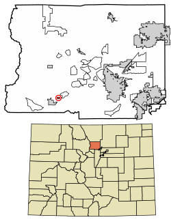
St. Anton Highlands or Saint Anton Highlands is an unincorporated community and a census-designated place located in and governed by Boulder County, Colorado, United States. The CDP is a part of the Boulder, CO Metropolitan Statistical Area. The population of the St. Anton Highlands CDP was 325 at the United States Census 2020. The Nederland post office serves the area.

4.7 km
Sugarloaf is an unincorporated community and a census-designated place located in and governed by Boulder County, Colorado, United States. The CDP is a part of the Boulder, CO Metropolitan Statistical Area. The population of the Sugarloaf CDP was 274 at the United States Census 2020. The Boulder post office serves the area.
5.3 km
Bonanza Mountain Estates is an unincorporated community and a census-designated place located in Boulder County, Colorado, United States. The CDP is a part of the Boulder, CO Metropolitan Statistical Area. The population of the Bonanza Mountain Estates CDP was 127 at the United States Census 2020. The Nederland post office serves the area.

5.6 km
Gold Hill is an unincorporated community and a census-designated place located in and governed by Boulder County, Colorado, United States. The CDP is a part of the Boulder, CO Metropolitan Statistical Area. The population of the Gold Hill CDP was 218 at the United States Census 2020. The Boulder post office serves the area.
Gold Hill is located to the northwest of Boulder, perched on a mountainside above Left Hand Canyon at an elevation of 8,300 feet. Originally a mining camp, it was the site of the first major discovery of gold during the 1859 Colorado Gold Rush and remained an important mining camp throughout the late 19th century, with a population approaching 1500 at its height, before falling into decline. It has been revived somewhat in recent years as a quiet, isolated haven, but easily accessible by dirt roads. The town contains numerous historic wooden structures, some restored in recent years, as well as decaying ruins from its mining heyday. It has a small museum and two-room schoolhouse, the Gold Hill School, which since 1873 has been the oldest continuously operating public school in Colorado. Other businesses include a General Store and the Gold Hill Inn, a restored inn listed on the National Register of Historic Places. The town is laid out on a small grid of unpaved streets.
Gold Hill is accessible from nearby Left Hand Canyon Road via Lick Skillet Road. Easier approaches to Gold Hill include Sunshine Canyon Road from 4th and Mapleton in Boulder, Gold Run Road from Salina, and Gold Hill Road from the Peak to Peak Highway south of Ward. All of these roads are susceptible to heavy snows during the winter, which at times render Gold Hill inaccessible to vehicles not equipped with chains or four-wheel drive.
Gold Hill is sometimes labeled a ghost town, which is an inaccurate designation. Gold Hill is part of unincorporated Boulder County, and while it does not have a municipal government, it does have an active town meeting with elected officials.
5.7 km
Tungsten is a ghost town in Boulder County, in the U.S. state of Colorado. The former townsite is north of Middle Boulder Creek.
The west end of the trail is listed on the National Register of Historic Places as the "Denver, Boulder and Western Railway Historic District".
