Location Image

All Saints' Church, Ugglebarnby

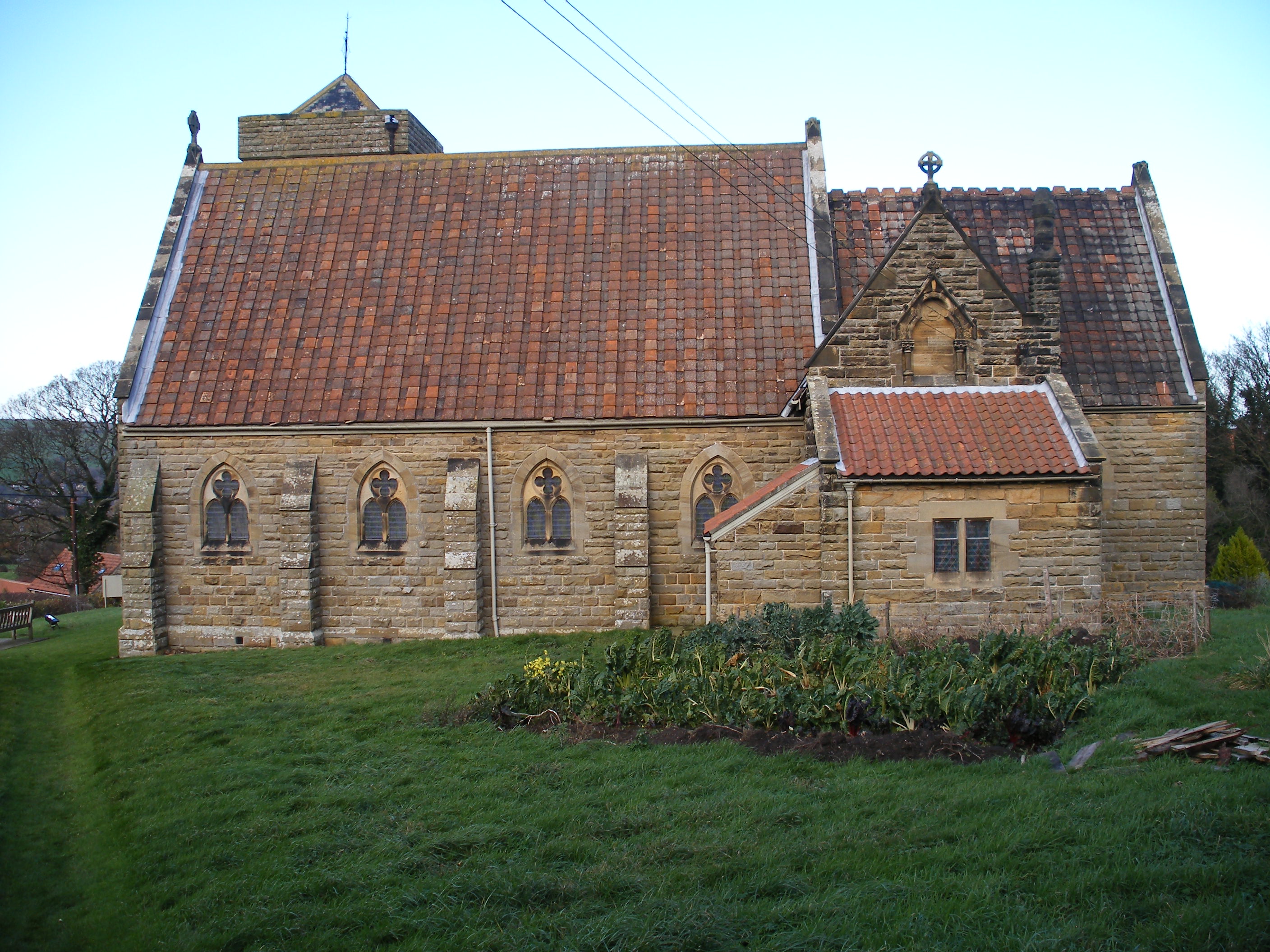
All Saints' Church is an Anglican church in Ugglebarnby, a village in North Yorkshire, in England. A chapel was constructed in Ugglebarnby in the 12th century. It is traditionally said to have been built in 1137, by Nicholas, Abbot of Whitby. The chapel was demolished in 1870 and a new church was completed in 1872, to a design by Charles Noel Armfield. It is broadly in the 14th-century Gothic style, but incorporates some stones from the old chapel. It was grade II listed in 1989.

The church is built of cream and red brick banding, faced in sandstone, with a roof of tile and pantile. It consists of a nave, a chancel with a south organ chamber and vestry, and a northwest tower. The tower has two stages, diagonal buttresses, a west doorway with a double-chamfered surround, a north window of three stepped lancets, two-light bell openings with pointed arches, a chamfered parapet band, and a plain parapet. Below the east window is a re-set carved stone. Inside the church is a stone reredos depicting the Last Supper, carved by Matthew Noble. There is a highly decorative carved pulpit and lectern, and a stone font, with an octagonal timber cover. There are carved pews, a brass altar rail depicting heraldic beasts, and a hammerbeam roof. There is much stained glass, described by Historic England as "pretty but unremarkable".

Nearby Places View Menu
Location Image
924 m

Ruswarp

Ruswarp ( RUS-əp) is a village in the civil parish of Whitby, in North Yorkshire, England. It is around 1.8 miles (2.9 km) from Whitby, at the junction of the B1410 and B1416 roads, on the River Esk and the Esk Valley Line, with trains stopping at Ruswarp railway station. Originally it was called Risewarp (Old English hrīs wearp, c. 1146) meaning 'silted land overgrown with brushwood'. Northern Rail serves the station and bus services connect the village to the surrounding area. The village is served by local shops including Jackson's of Ruswarp, and Colin Duck Grocer and Off-licence. There is a pub, the Bridge Inn, and a parish church, St Bartholomew. Primary education is catered for by Ruswarp Church of England primary school. There was a Post Office on the high street which closed down several years ago after losing the franchise, and is now converted into a private residence. Crossing the River Esk downstream is a railway viaduct, 120 feet high, built (using 5,250,000 bricks) to carry the Scarborough-to-Whitby line, which closed in 1965. The viaduct is now owned by Sustrans and carries "The Cinder Track", a footpath/cyclepath along the former Whitby-to-Scarborough railway line. The River Esk was used to power corn mills in the village but the last closed in 1962. The weir that was built to channel water into a mill race has been adapted to power a hydro-electric project on its southern bank. The Ruswarp Hydro project started generating electricity in December 2012. The village lies on the Esk Valley Walk, a national long-distance footpath. There is a physically undemanding walk between Ruswarp and Whitby (approximately 1½ miles) mostly along a stone pannierway known as Monks Trod, signposted from the main street in Ruswarp. The village also hosts one of the area's tourist attractions, Esk Leisure, which consists of Mini Monsterz Indoor Play with pottery painting and laser tag. Also at Esk Leisure is Outdoor Laser Combat and a Farm Park, previously a 9-hole Pitch and Putt course, which closed in October 2009. Opposite Esk Leisure is Ruswarp Pleasure Boats, established in 1874, where rowing boats or canoes can be rented to explore the sheltered waters that offer a unique opportunity to access the only migratory Salmon river in Yorkshire. There is also a miniature steam railway for children and adults. Ruswarp Village Hall caters for community events and classes. The local Church of England parish is Whitby with Ruswarp, which falls within the boundaries of the Diocese of York and is overseen by the suffragan Bishop of Whitby. Ruswarp was formerly a township in the parish of Whitby, in 1866 Ruswarp became a separate civil parish, on 1 April 1925 the parish was abolished and merged with Whitby. In 1921 the parish had a population of 6195. Until 1974 it was in the North Riding of Yorkshire. From 1974 to 2023 it was part of the Borough of Scarborough, it is now administered by the unitary North Yorkshire Council.
Location Image
1.2 km

Sleights

Sleights ( SLITES) is a village in North Yorkshire, England. Located in the Esk Valley in the postal region of Whitby, the village is part of the civil parish of Eskdaleside cum Ugglebarnby. Sleights lies along the steep main A169 road that runs north to south between Whitby and Malton via Pickering across the North York Moors. At the bottom of the village, the road crosses the Esk Valley Railway, allowing access to Sleights railway station. The road crosses the River Esk on a high bridge, opened on 26 January 1937. The road continues up the hill to reach the A171 Whitby to Middlesbrough trunk road. At the top of the village is Blue Bank. Due east of the village is the hamlet of Iburndale. Due to road accidents, Blue Bank, with a gradient of 1 in 4 (25%), has an escape lane of soft sand. From 1974 to 2023 it was part of the Borough of Scarborough, it is now administered by the unitary North Yorkshire Council. The Horticultural & Industrial Society show has been held each year since 1880. Since 2006 the show has been held on the sports field, with classes for produce, fruit, flowers vegetables, crafts, cake decorating, photography, flower arranging etc. Additional attractions include a bouncy castle, face painting, tombola and a fun dog show. The infamous Victorian forger Edward Simpson was born here in 1815.
Location Image
1.3 km

St John's Church, Sleights

St John's Church is an Anglican church in Sleights, a village in North Yorkshire, in England. The mediaeval St John's Chapel, Sleights, was replaced by a new building, further down the hill, in 1767. In 1848, it was described as a "very elegant structure". However, the Georgian church was demolished and replaced with a new building, which was consecrated on 20 September 1895. The church was designed by Ewan Christian in the Early English style. It was grade II listed in 2005. The church is built of Grosmont sandstone, with a roof of Westmorland slate. It consists of a nave, a north aisle, a north transept, a chancel, and a northeast tower with a plain parapet and a pyramidal roof. The windows are lancets, and the east window is a stepped tripled lancet. The stained glass was designed by Charles Eamer Kempe. Inside, there is a hammerbeam roof, oak panelling to the lower parts of the walls, and an oak reredos and altar. In the churchyard is the grade II listed Coates Memorial, commemorating members of the Coates family. It constructed of sandstone with a square plan, and consists of a concave obelisk, standing on a moulded base decorated with acanthus. On the sides are memorial panels surrounded by rinceaux in low relief.
Location Image
1.5 km

Sneaton

Sneaton is a village and civil parish in the county of North Yorkshire, England. The Anglican St Hilda's Church, Sneaton lies in the village. According to the 2011 UK census, Sneaton parish had a population of 178, a decrease on the 2001 UK census figure of 190. From 1974 to 2023 it was part of the Borough of Scarborough, it is now administered by the unitary North Yorkshire Council. The name Sneaton possibly derives from the Old Norse personal name Snaer or Snjo, and the Old English tūn meaning 'settlement'. Alternatively, the first element may be derived from the Old English snǣd meaning 'a cut off piece of land'. Two miles from the village on the outskirts of Whitby is the 19th century Sneaton Castle. The castle adjoins St. Hilda's Priory, the Mother Church of the Order of the Holy Paraclete.