
 English
 Français

Kilconquhar
Kilconquhar ( , locally also kih-NYUKH-ər) is a village and parish in Fife in Scotland. It includes the small hamlet of Barnyards. It is bounded by the parishes of Elie, Ceres, Cameron, St Monans, Carnbee, Newburn and Largo. It is approximately 9 miles from north to south. Much of the land is agricultural or wooded. The village itself is situated inland, north of Kilconquhar Loch. Also in the civil parish are Colinsburgh and Largoward, the latter since 1860 being a separate ecclesiastical parish. The coastal village and royal burgh of Earlsferry was formerly in the parish, but in 1891 the burgh and that part of the parish south of the (now disused) Fife Coast Railway line and Cocklemill Burn was transferred to the parish of Elie.
Nearby Places View Menu

367 m
Elie House
Elie House is a country house in Elie, Fife, Scotland. It is a Category A listed building.
The house, built in 1697 and incorporating an earlier structure, is south facing, constructed in stone in 3 storeys, 2 bays deep with a 5-bay frontage. Later additions were made c.1770 and in 1854–55.

896 m
Elie Primary School
Elie Primary School is a school in Elie, Fife, Scotland. It is located partly in a Category C listed building dating from 1858. The architect of the relevant north block was Elie native John Currie.
924 m
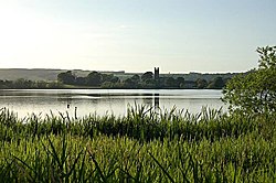
Kilconquhar Loch
Kilconquhar Loch is a Scottish freshwater loch.
This small shallow loch is a Site of Special Scientific Interest (SSSI) and is located beside the village of the same name in the east of Fife, within a mile to the north of the coastal village of Elie.
The loch appears to be a comparatively recent feature, the earliest reference being to "the gret loch callit of auld the Reidmyre" (Scots: red or reed peat bog) in 1599 and referred to as Keanwchar Loch by 1654 in Blaeu's Atlas Novus. Samples of the loch bed support its origin as a bog and there is archaeological evidence and a local tradition that fuel was extracted. Westward outflow to the Cocklemill Burn is said to have been blocked by sand in 1624 or 1625 but it is drained to the south-east by the largely underground Loch Run into Elie harbour and eastwards to the Inverie Burn.
It is an approximate rounded square in shape, and is unusual in that it has no visible inflow, yet is not stagnant. It is the subject of a study by St. Andrews University. It has been theorised that an underground spring feeds into the loch, maintaining a degree of freshness sufficient to offset its stagnation.
In former times it was reported to produce large pike and eels, although this is now no longer verifiable as no fishing is allowed, due to its SSSI status.
Large numbers of overwintering wildfowl use Kilconquhar Loch as a roost.
It was charted during the Bathymetrical Survey of the Fresh-Water Lochs of Scotland, constructed under the direction of Sir John Murray and Laurence Pullar during the years 1897 to 1909.

999 m
Elie railway station
Elie railway station served the town of Elie and Earlsferry, Fife, Scotland, from 1863 to 1965 on the Fife Coast Railway.