
 English
 Français

Gare de Walsden
La gare de Walsden est une gare ferroviaire du Royaume-Uni, située sur le territoire de la ville de Walsden, dans le Yorkshire de l'Ouest en Angleterre. Les services à partir de Walsden sont opérés par Northern Rail.
Nearby Places View Menu

222 m
Walsden railway station
Walsden railway station (; WOLZ-dən) serves the village of Walsden, Todmorden in West Yorkshire, England, on the edge of the Pennines.
It is served by the Calder Valley line operated by Northern. The station is 32 miles (51 km) west of Leeds and 17.25 miles (28 km) north east of Manchester Victoria. Walsden is the last station before the boundary with Greater Manchester. The station was opened by Metro (West Yorkshire Passenger Transport Executive) on 10 September 1990 as a replacement for an earlier structure that closed on 6 August 1961. This earlier station, which was opened in 1845 by the Manchester & Leeds Railway, predecessor of the Lancashire & Yorkshire Railway, was situated between the level crossing and the north portal of Winterbutlee Tunnel, a few yards south of the present station.

484 m
Walsden
Walsden (; WOLZ-dən) is a large village in the civil parish of Todmorden in the Metropolitan Borough of Calderdale, West Yorkshire, England.
It was historically partially administered in Lancashire (the Walsden Water as tributary to the Calder serving as the county boundary), and close to the modern boundary with Greater Manchester. It lies along the A6033 Keighley to Littleborough road in the Walsden Valley, a branch of the Upper Calder Valley, and is 2 miles (3.2 km) south of Todmorden and 4 miles (6.4 km) north of Littleborough.
1.4 km
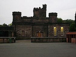
Dobroyd Castle
Dobroyd Castle is an important historic building above the town of Todmorden, West Yorkshire, England. It was built for John Fielden, local mill owner and son of Honest John Fielden the Social Reformer and MP.
The building has had a varied past. First built as an extravagant mansion house, then it was used as a school, it then became a Buddhist Retreat centre and the building is currently used as an Activity Centre (Known as Robinwood) for Primary School Groups.
The castle has 66 rooms and is Grade II* listed.

1.5 km
Todmorden Unitarian Church
Todmorden Unitarian Church is a Unitarian church located on Honey Hole Road, Todmorden, West Yorkshire, England (grid reference SD935239). Built in honour of John Fielden, a local mill owner and a social reformer, the church was completed in 1869. It was declared redundant in 1987 and came under the care of the Historic Chapels Trust. Since 2008, regular services have been held in the building, but it remains in the care of the Trust. The church is recorded in the National Heritage List for England as a designated Grade I listed building,
1.7 km
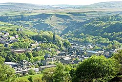
Todmorden
Todmorden ( TOD-mər-dən; locally ) is a market town and civil parish in the Upper Calder Valley in Calderdale, West Yorkshire, England. It is 17 miles (27 kilometres) north-east of Manchester, 8 miles (13 km) south-east of Burnley and 9 miles (14 km) west of Halifax. In 2011, it had a population of 15,481.
Todmorden is at the confluence of three steep-sided Pennine valleys and is surrounded by moorlands with outcrops of sandblasted gritstone.
The historic boundary between Yorkshire and Lancashire is the River Calder and its tributary, Walsden Water, which run through the town. The administrative border was altered by the Local Government Act 1888 placing the whole of the town within the West Riding.
The town is served by Todmorden and Walsden railway stations.