
 English
 Français

Daer Water
Daer Water (Scots: daer; [døːɾ] and [deːɾ], northern Scotland [diːɾ]) is one of the streams located in the watershed region which surrounds the River Clyde in Scotland. It begins in the Lowther Hills about 600 metres (2,000 ft) above sea level and joins with Potrail Water near the Lanarkshire town of Elvanfoot at which point they become the River Clyde. The Daer Water flows through the Daer Reservoir which supplies water to the nearby towns of Lanarkshire.
Nearby Places View Menu
1.3 km
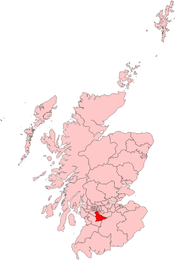
East Kilbride, Strathaven and Lesmahagow
East Kilbride, Strathaven and Lesmahagow was a county constituency of the House of Commons of the Parliament of the United Kingdom, which was first used in the general election of 2005. It replaced East Kilbride and some of Clydesdale, and it elected one Member of Parliament (MP) by the first past the post system of election.
Further to the completion of the 2023 Periodic Review of Westminster constituencies, the seat was subject to boundary changes which included the loss of Lesmahagow. As a consequence, the relevant seat was renamed East Kilbride and Strathaven, first contested at the 2024 general election.

4.4 km
Daer Reservoir
Daer Reservoir is a man-made waterbody created by the damming of the Daer Water, a tributary of the River Clyde in the Southern Uplands of Scotland. It lies within the Lowther Hills in South Lanarkshire. It is accessible by a minor public road leaving the A702 follows the Daer Water south to the dam and then continues along the western margin of the reservoir as far as Kirkhope. The reservoir was officially opened by Elizabeth II in 1956 to supply water to the Scottish Central Belt.

4.7 km
Beattock Summit
Beattock Summit is the highest point of the West Coast Main Line (WCML) railway and of the A74(M) motorway as they cross between Dumfries and Galloway and South Lanarkshire in south west Scotland.
The height of the summit reached by the A74(M) motorway is 1,033 feet (315 m) above sea level. The adjacent railway reaches a slightly lower elevation of 1,016 feet (310 m). The summit is the watershed between the River Clyde to the north and Evan Water, a tributary of the River Annan to the south.

5.3 km
Elvanfoot railway station
Elvanfoot railway station was a station which served Elvanfoot, in the Scottish county of South Lanarkshire. It was served by local trains on what is now known as the West Coast Main Line.