


The East and West Blockhouses were Device Forts built by King Henry VIII in 1539 to protect the harbour of Milford Haven in Wales. The two blockhouses were positioned on either side of the Milford Haven Waterway in the villages of Angle and Dale respectively, overlooking the sea. The East Blockhouse was never completed, but the remains were reused as a defensive site in the Second World War.
Gallery

Sponsored
Location
1 explorer visited this place

1.2 km
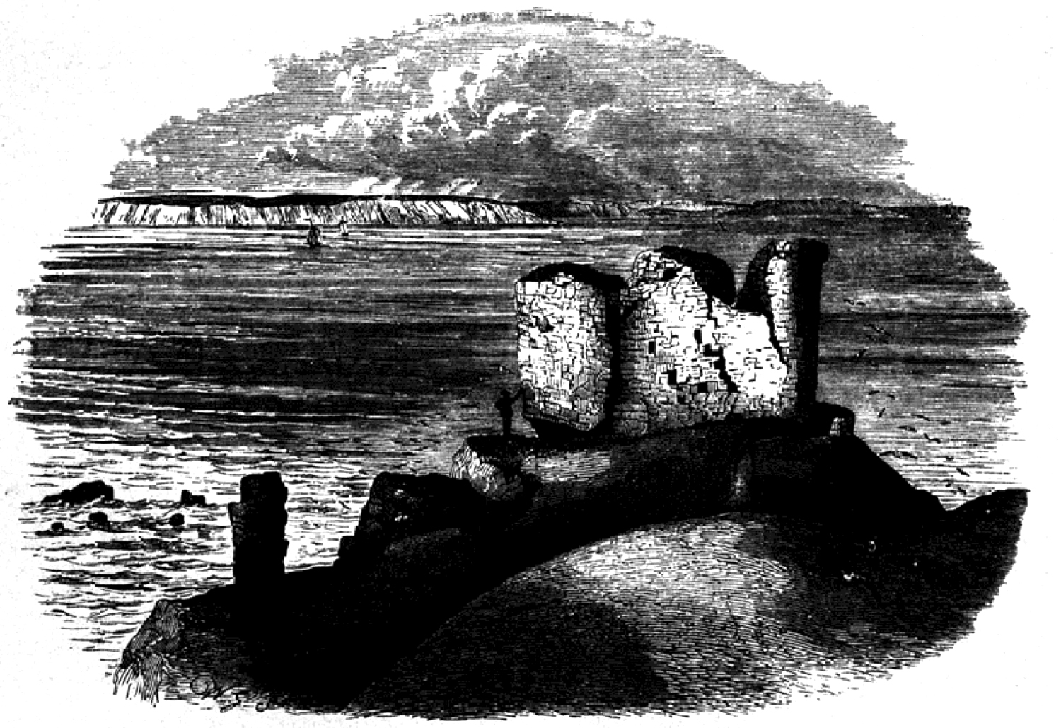
Thorne Island is a rocky islet and part of the community of Angle, Pembrokeshire, Wales, with an area of 2 acres, dominated by a coastal artillery fort built to defend the Milford Haven Waterway in the mid-19th century. It has been the site of a number of shipwrecks, including one in 1894 that was carrying a cargo of Scotch whisky.

1.8 km
The Angle Peninsula Coast on the southern side of the entrance to the Milford Haven Waterway in Pembrokeshire, Wales, is a Site of Special Scientific Interest. There is a wide range of wildlife and a former Royal Air Force station.
The peninsula is rich in Second World War defences and the site of the former air base RAF Angle. The hollows in the banks around it were used to house machine guns in the Second World War and there was a searchlight battery here. Inland from East Picket bay are the remnants of the E-Pens used to house fighter aircraft if they were needed. In a field close to the World War I memorial there are the remains of an anti-aircraft post. On a section of the coastal path just past the RNLI lifeboat house there are visible remains of an anti-aircraft post. This site was later changed and used to house a 40 mm Rolls-Royce cannon. At the north hill, there are remains of a Laing hut that was used as housing for a searchlight. On a rocky patch of ground at west pill is a brick mine watcher hut. This was used specifically to watch out for the enemy who may be laying mines in Milford Haven.
RAF Angle was an airfield during World War II. It opened in 1941 after Luftwaffe attacks against Pembroke Dock. The airfield, which began as a station for No. 10 Group, Fighter Command, housed several squadrons during the war such as No. 312 Squadron RAF and the Canadian 412 Transport Squadron. Planes included Supermarine Spitfires, Westland Whirlwinds and Hawker Hurricanes. In 1943 operational control passed on to the Fleet Air Arm of the Royal Navy. During this time a Sunderland flying boat landed at Angle airfield after receiving hull damage during a rescue. It returned to the RAF and became home to the Coastal command unit who tested weapons that could be used against German U-boats. After the war was over the buildings were no longer used and many were removed in the 1980s; however, some still stand in remote locations.
On 15 February 1996, the oil tanker Sea Empress grounded at the Milford Haven Waterway entrance, spilling 72,000 tonnes of crude oil.
The coastline around Angle was severely damaged. The effect of the oil spill lasted several years and cost £60 million.

2.0 km
Royal Air Force Angle or more commonly RAF Angle is a former Royal Air Force station located on the Angle Peninsula Coast, 8 miles west of Pembroke, Pembrokeshire, Wales. It was operational from 1 June 1941 to 11 July 1946, having been used by both the Royal Air Force and the Royal Navy.
The village of Angle is 0.5 miles north of the airfield, which is located along the coast. Notable landmarks are, Freshwater West beach to the south of the airfield, and the St. Gowans lightship, 8 miles south of Linney Head.
The airfield opened as an RAF Fighter Command forward airfield, within No. 10 Group RAF as part of the Fairwood Common Sector. During the previous year the Luftwaffe had attacked Pembroke Docks and Milford Haven with the freedom from any consequences of air defences, causing a furore at high levels of state, and highlighting the need for anti-aircraft operations for the whole of the area.

2.0 km
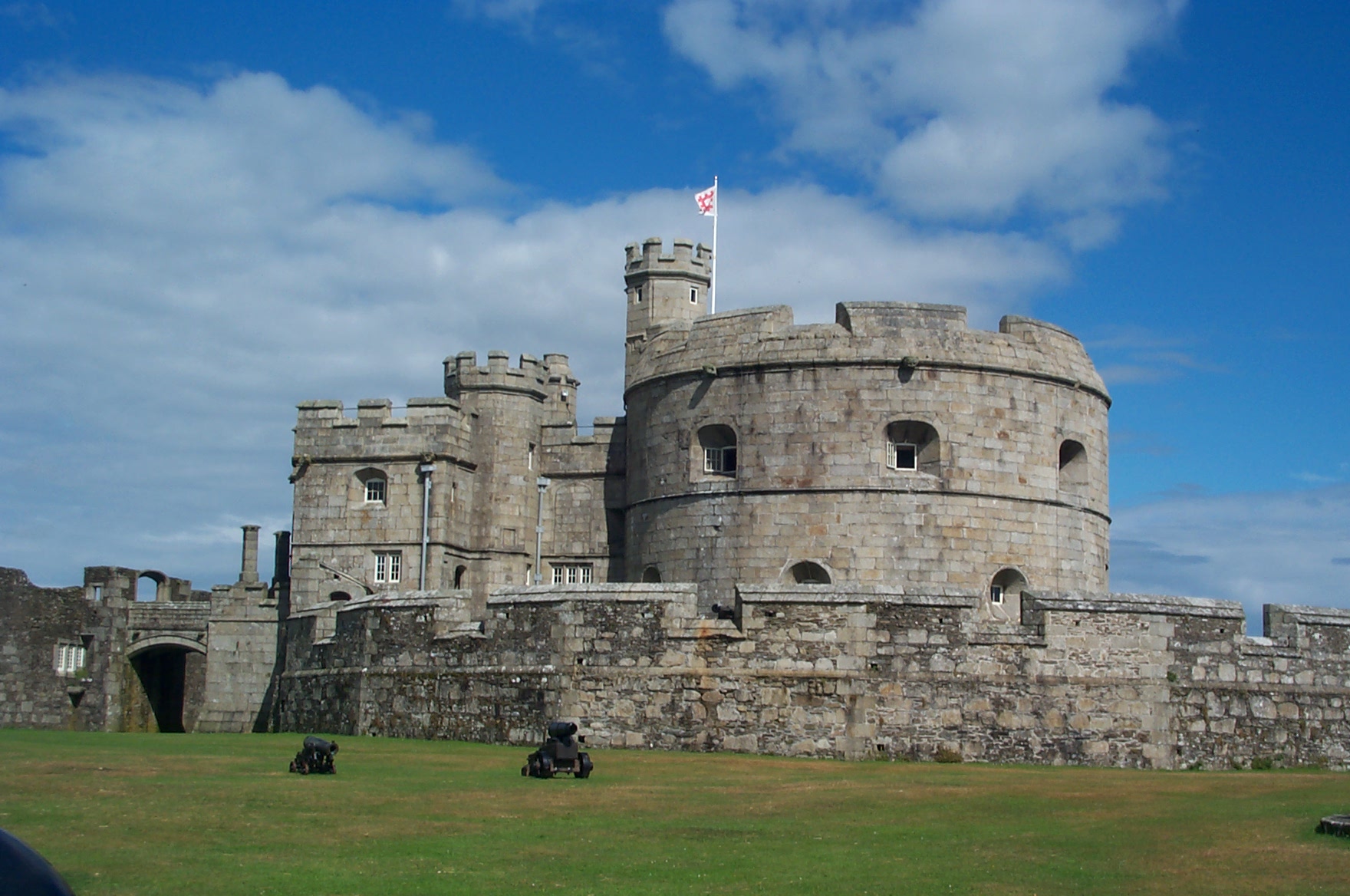
Chapel Bay Fort is located on the southern shore of the Milford Haven Waterway, Pembrokeshire, Wales. The fort is approximately 1 mile from the village of Angle. One of a series of forts built as part of the inner line of defence of the Haven following the Royal Commission on the Defence of the United Kingdom, it is a Grade II Listed Building. and is also known as "Chapel Bay Battery".
Construction began in 1890 and was completed in 1891 at a cost of £11,779. The battery was the first fortification in the area to be built of mass concrete. It could accommodate 91 men and had mess room and sick bay facilities. Its initial armament was three ten inch rifled muzzle-loading guns.
From June 1900 until August 1901, the battery was reconstructed to take more modern armament - three 6-inch breech-loading guns. Throughout the First World War, the fort remained in military hands, but it was decommissioned in 1920. It was sold to the Angle Estate in 1932. The battery was used during the Second World War when a mining observation post was built on the site. In recent years the fort was acquired privately and now functions as a museum, following a £500,000 grant from the Welsh Assembly. One of the fort's original 10-inch guns has been re-mounted as part of the restoration. The site opened to the public in April 2015.

2.1 km
Milford Haven Waterway is a natural harbour in Pembrokeshire, Wales. It is a ria or drowned valley which was flooded at the end of the last ice age. The Daugleddau estuary winds west to the sea. As one of the deepest natural harbours in the world, it is a busy shipping channel, trafficked by ferries from Pembroke Dock to Ireland, oil tankers and pleasure craft. Admiral Horatio Nelson, visiting the haven with the Hamiltons, described it as the next best natural harbour to Trincomalee in Ceylon and "the finest port in Christendom". Much of the coastline of the Waterway is designated as a Site of Special Scientific Interest, listed as Milford Haven Waterway SSSI.
The West Blockhouse was described by contemporaries as forming a round tower with gunports, but it was demolished when West Blockhouse Fort was built on the same site in the 19th century.