
 English
 Français
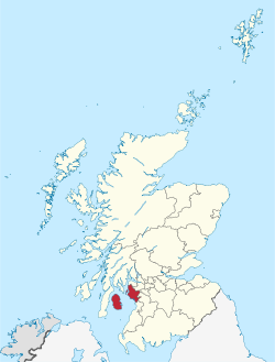
North Ayrshire
Le North Ayrshire (en gaélique écossais : Siorrachd Inbhir Àir a Tuath) est une des 32 divisions administratives de l’Écosse. Elle représente une grande partie de l’ancien comté d’Ayrshire.
Nearby Places View Menu

0 m
North Ayrshire
North Ayrshire (Scottish Gaelic: Siorrachd Àir a Tuath, pronounced [ˈʃirˠəxk aːɾʲ ə ˈt̪ʰuə]) is one of 32 council areas in Scotland. The council area borders Inverclyde to the north, Renfrewshire and East Renfrewshire to the northeast, and East Ayrshire and South Ayrshire to the east and south respectively. The local authority is North Ayrshire Council, formed in 1996 with the same boundaries as the district of Cunninghame, which existed from 1975 to 1996.
Located in the west central Lowlands with the Firth of Clyde to its west, the council area covers the northern portion of the historic county of Ayrshire, in addition to the islands of Arran and The Cumbraes from the historic county of Buteshire. North Ayrshire had an estimated population of 134,010 in 2024. Its largest towns are Irvine and Kilwinning. From 1975 to 1996 under the name Cunninghame it was one of nineteen local government districts in the Strathclyde region.

2.1 km
Ardrossan Wind Farm
The 24 megawatt (MW) Ardrossan Wind Farm in Ardrossan, North Ayrshire, Scotland was officially opened on 10 August 2004. The Vestas factory in Argyll, which now employs more than 200 people, has supplied the wind turbines for the Airtricity development. The company is providing access to the site for schools and other interested community groups to learn more about wind power.
The Guardian has reported that the Ardrossan Wind Farm has been "overwhelmingly accepted by local people". A local councillor wrote that "The turbines are impressive looking, bring a calming effect to the town and, contrary to the belief that they would be noisy, we have found them to be silent workhorses".
In the Hurricane Bawbag storms of December 2011, one of the turbines of the wind farm catastrophically failed in a ball of fire.

2.5 km
Ashgrove Loch
Ashgrove Loch, also known as Stevenston Loch, is a mesotrophic lochan (small loch) in North Ayrshire, Scotland, approximately 2 km northeast of the town of Stevenston.
Due to artificial drains, known as cunnels, approximately 90% of the lochan's surface is covered by floating vegetation and is classed as a fen. The lochan sustains rich plant life, including two rare species, Lysimachia thyrsiflora and Cicuta virosa.
Many bird species also use the lochan, including the grasshopper and sedge warblers.
Ashgrove Loch sits on a bed of Carboniferous limestone and thus has a high mineral content.
The lochan's primary outflow, Loch Canal, is an artificial burn regulated by a sluice at Lochend, having previously powered a watermill there.

2.6 km
Montfode Castle
The remains of the old castle of Montfode or Monfode lie to the north-west of the town of Ardrossan and 1.5 miles (2.4 km) south-west of West Kilbride in North Ayrshire, Scotland, above the Montfode Braes (above the raised beach cliffs), in the old Barony of Kilbride. The remains of the 16th-century tower are protected as a scheduled monument. The castle ruins are clearly visible from the A78 Ardrossan bypass.

2.6 km
Ardrossan Academy
Ardrossan Academy is an 11–18 secondary school in Ardrossan, North Ayrshire, Scotland, opened in October 1882, serving the town of Ardrossan, with pupils also coming from nearby Saltcoats, West Kilbride, Seamill, Fairlie, Largs and other areas. As of November 2025, the current Head Teacher of the school is Anne Anderson.