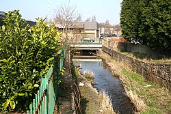
Barrowford ( ) is a village and civil parish in the Pendle district of Lancashire, England, north of Nelson, near the Forest of Bowland Area of Outstanding Natural Beauty. Barrowford is on the Marsden–Gisburn–Long Preston turnpike. One of the original toll houses can still be seen at the junction with the road to Colne. The toll house was restored in the 1980s and is owned by the trust which operates nearby Pendle Heritage Centre. Barrowford is about half a mile from the Leeds and Liverpool Canal, and a set of seven locks leads to the highest section of the canal between Barrowford and Barnoldswick. About a mile on from the locks heading towards Leeds is Foulridge Tunnel known locally as the "Mile Tunnel". The packhorse bridge near Higherford Mill is the oldest in Barrowford, dating to the end of the 16th century. It formerly lay on the old main road to Gisburn, which was superseded by the Turnpike road built in 1804. The modern Anglican church (St Thomas') was built to replace the original church of 1839, which burnt down in 1964. The village has two rivers: Pendle Water, which flows through it, and Colne Water, which joins Pendle Water behind the site of the now demolished Samuel Holden cotton mill and flows down from the moors above Colne. The first residential home for the deaf in Lancashire was established at Barrowford in 1929.

Nearby Places View Menu
Location Image
636 m

Colne Water

Colne Water is a river in eastern Lancashire. It is approximately 5.0 miles (7.987 km) long and has a catchment area excluding its major tributaries (the River Laneshaw, Wycoller Beck, Trawden Brook and Wanless Water) of 4.47 square miles (11.584 km2). Colne Water is formed at the Covey Bridge near Laneshaw Bridge by the confluence of the River Laneshaw and Wycoller Beck. From there, the river runs in a westerly direction toward the town of Colne, collecting Trawden Brook at Cottontree. It continues through Colne's south valley, meeting Church Clough Brook in the Waterside area and passing under the East Lancashire railway line viaduct and the A56 Burnley Road at Primet Bridge. It is joined by Guy Syke at the Greenfield Bridge and passes the town's sewage works as it leaves, shortly afterwards collecting Wanless Water and then Swinden Clough just before it passes under the Leeds and Liverpool Canal. It joins Pendle Water at the Lowerford part of Barrowford, just after the M65 motorway bridge. The name Colne possibly originates from the ancient British language, but the meaning is uncertain. It is thought that the town takes its name from the river. Water (OE wæter) is a common name for a stream, most often found in southern Scotland.
Location Image
973 m

Walverden Water

Walverden Water is a minor river in Lancashire, England. It is approximately 2.6 miles (4.2 km) long and has a catchment area of 5.04 square miles (1,304.23 ha).
992 m

Nelson power station

Nelson power station supplied electricity to the town of Nelson, Lancashire and the surrounding area from 1892 to 1960. The power station was owned and operated by Nelson Corporation prior to the nationalisation of the British electricity supply industry in 1948. It was redeveloped in 1922 to 1925 to meet the increased demand for electricity.
Location Image
1.1 km

Seedhill Cricket Ground

The Seedhill Cricket Ground is a small cricket stadium in the English town of Nelson, Lancashire. It is the home of Lancashire League cricket team Nelson Cricket Club. It is situated near to Seedhill Football Ground, the former home of North West Counties League Division One side Nelson F.C. and its home during its period in the Football League from 1921 to 1931, during which time it won the Third Division North title in 1922-23 and played in the then Second Division the following season. The ground hosted nine of Lancashire's first-class matches (all in the County Championship) between 1925 and 1938. In 2001 it staged its only List A game, when the Lancashire Cricket Board lost to the Yorkshire Cricket Board in the first round of the C&G Trophy.