
 English
 Français

Woodlesford
Woodlesford ( WUUD-əlz-fərd) is a suburban village in the City of Leeds, West Yorkshire, England, 6 miles (10 km) south-east of Leeds city centre. Formerly part of the Rothwell Urban District, it is now within the Rothwell ward of Leeds City Council. The village sits on the banks of the Aire and Calder Navigation and river system.
Nearby Places View Menu

627 m
Woodlesford railway station
Woodlesford railway station serves a suburban village of Woodlesford and a town of Rothwell in West Yorkshire, England. It lies on the Hallam Line and the Pontefract Line, 6 miles (9.7 km) south of Leeds.
986 m
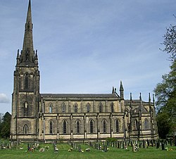
St John the Evangelist's Church, Oulton
St John the Evangelist's Church, Oulton, West Yorkshire, England is an active Anglican parish church in the archdeaconry of Leeds and the Diocese of Leeds.
1.1 km
West Riding County Football Association
The West Riding County Football Association is the governing body of football in northern parts of the West Riding of Yorkshire, England. Its headquarters are in the village of Woodlesford, 6 miles (9.7 km) south east of Leeds.
Affiliated members pay a fee commensurate with the level of competition they play in. Affiliated members benefit from access to support and guidance on such areas as health and safety and access to finance or grants. The County FA is directly responsible for the governance of County Cup competitions.

1.2 km