


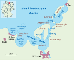
L'île de Poel (en allemand : Insel Poel) est une île allemande en mer Baltique dans le Land de Mecklembourg-Poméranie-Occidentale d'environ 36 km2 et 2 485 habitants en 2018. Elle est située en face de la ville de Wismar et appartient comme commune à l'arrondissement du Mecklembourg-du-Nord-Ouest (Landkreis Nordwestmecklenburg).
Gallery

Sponsored
Location
0 m
Poel or Poel Island, is an island in the Baltic Sea. It forms the natural northern and eastern boundaries of the Bay of Wismar on the German coast. The northern coast of the island is also on the south side of the large gulf known as the Bay of Mecklenburg, which Wismar Bay enters into. Insel Poel thus forms on its northern side the unofficial latitude of the northern boundary of the Wismar Bay.
It is close to the cities of Lübeck, Wismar and Schwerin and is part of the Hamburg Metropolitan Region.
Administratively it is a municipality in the Nordwestmecklenburg district. It consists of Kirchdorf and Oertzenhof and the smaller villages of Timmendorf, Wangern, Hinterwangern, Weitendorf, Weitendorf-Hof, Brandenhusen, Neuhof, Seedorf, Niendorf, Schwarzer Busch, Kaltenhof, Fährdorf, Malchow, Vorwerk and Gollwitz. It covers an area of 36.02 km2 and has 2,873 citizens. Satellite pictures show that most of it is used as farmland. With its good air, clean water, fine beaches and sheltered harbours, it is also popular recreational area. At Timmendorf harbour there are a pilot's station and facilities for yachts and local fishermen. Kirchdorf has a yachting harbour and a boatyard. Wismar Bay is cited by the Encyclopædia Britannica Eleventh Edition as the finest harbor on the Baltic.
The island's name derives from pole, the Common Slavic word for "flat land" or "field".

1.9 km
Kirchsee, near the island of Poel, is part of Wismar Bay in Mecklenburg-Vorpommern, Germany. The bay cuts deeply into the island of Poel from the south.
It is named after the main town on the island of Poel, Kirchdorf. The bay is approximately three kilometers long and up to one kilometer wide at its southern end. The southern opening is formed by the two sand spits, Fährdorfer Haken and Brandenhusener Haken, which were created by wind and currents. The shores of the Kirchsee are very diverse, alternating between cliff coasts, flat sandy shores, and smaller alluvial areas. Kirchsee is a shallow body of water, mostly less than two meters deep. Only the navigation channel leading to the port of Kirchdorf is deeper. Maintaining the navigation channel also ensures Kirchsee’s access to the sea, as this access would otherwise silt up.

3.0 km
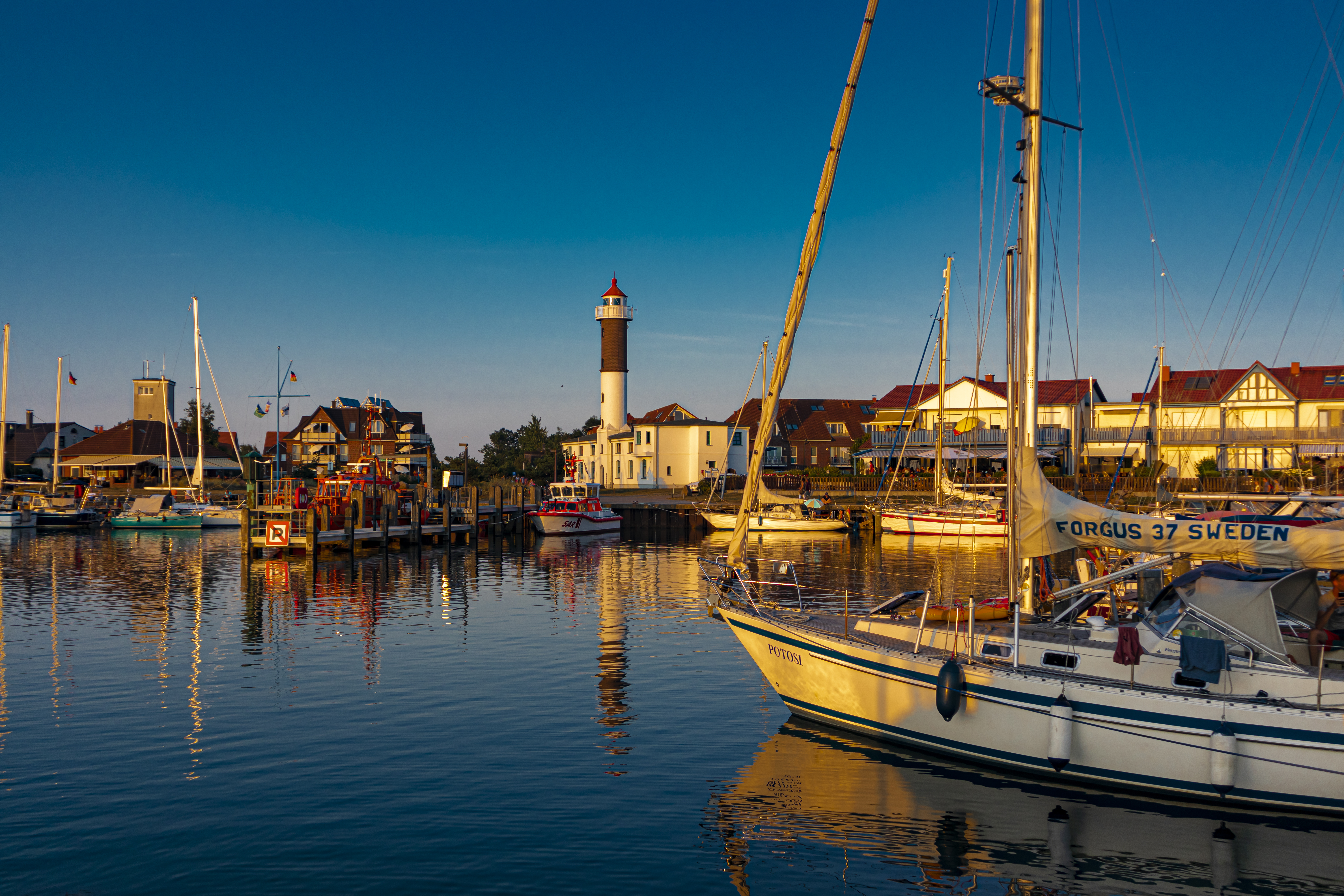
Timmendorf is part of the municipality of Insel Poel on the Baltic Sea island of the same name in the district of Nordwestmecklenburg in the German state of Mecklenburg-Vorpommern. Timmendorf lies on the west coast of the island of Poel and is divided into the villages of Timmendorf and Timmendorf Strand, which are about a kilometre from one another. A prominent landmark in Timmendorf Strand and sea mark for the navigation of shipping in the Bay of Wismar is Timmendorf Lighthouse. A little to the north of the lighthouse there is a pilot's house with a tower. The settlement has a one-kilometre-long sandy beach and a small harbour in which sports boats, fishing vessels and a pilot boat are moored. The tourist infrastructure includes various holiday apartments, a large campsite and several restaurants. In summer the beach of Timmendorf Strand is packed with visiting bathers and the harbour of Timmendorf is full of yachts.
3.8 km
The Breitling is a narrow strait in the Baltic Sea between the island of Poel and the mainland in the northeast of the district of Nordwestmecklenburg. It links the sheltered part of the Bay of Wismar, beginning south of Poeldamm, with the Salzhaff.
The Breitling is a very shallow body of water, mostly under one metre in depth. Large parts can even become exposed at low water, whereas at high water it can cover the low-lying causeway known as the Poeldamm. In the south the road link runs along a causeway over a low peninsula to Poel over the Breitling. The waterbody is about five kilometres long and no more than one kilometre wide.

4.4 km
Ahrendsberg is an uninhabited island, 8.6 hectares in area, near the island of Poel in the Breitling, a strait off the Bay of Wismar on the Baltic coast of Germany.
The island, which is roughly 600 metres long and up to 220 metres wide, is dominated by salt meadows with shores that are dissected by creeks. The higher areas are generally very dry, nutrient-poor, and are characterised by stunted vegetation, for example dry, lean grassland with thistle and sand thyme. At the southern tip of the island is a short section of cliff.
Book your tour near
Poel
Book Now
4.5
in partnership with
GetYourGuide.com