


Salisbury ( SAWLZ-br-ee) is a northern suburb of Adelaide, South Australia. It is the seat of the City of Salisbury, and is within the South Australian Legislative Assembly electoral district of Ramsay and the Australian House of Representatives division of Spence. The suburb is a service area for the City of Salisbury district, with many parklands, shops, cafés and restaurants.
Gallery


Sponsored
Location
1 explorer visited this place

91 m
Salisbury railway station is a railway station and bus interchange in the northern Adelaide suburb of Salisbury. It is on the Gawler line, 20.2 kilometres from Adelaide station. Adjoining it is a large park & ride carpark, making it one of the busiest stations on the Adelaide suburban rail system.

697 m
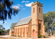
St Augustine's Catholic Church in the Salisbury Catholic Parish forms part of the Catholic Archdiocese of Adelaide. Located in the northern suburbs of the city of Adelaide, South Australia, the parish's boundaries roughly coincide with the limits of the City of Salisbury.
In the Salisbury Catholic Parish, there are three mass centres: St Augustine, St Finbar, the Holy Family; three parish schools: St Augustine School, Holy Family School, and Thomas More College; the Pioneer cemetery; and some parish and migrant groups and communities, as well as charities.
The Parish celebrates a biannual carnival on the eve of Lent.
871 m
Salisbury High School is a secondary public school located at 14 Farley Grove in the suburb of Salisbury North, Adelaide, South Australia. Established in 1959, in 2023 Salisbury High School had a student population of 1061 and employed 79 teaching staff. There are currently four school houses: Cairns, Florey, Mawson, and Oliphant.
In 2005, Salisbury High School became an IB World School but converted back to an Australian Curriculum school in 2016.
873 m
The District Council of Yatala North was a local government area of South Australia on the central Adelaide Plains from 1868 to 1933. It was split from the abolished District Council of Yatala on 18 June 1868. The council area ranged approximately from Dry Creek in the south to the Little Para River in the north.