


Le Chicago Sanitary and Ship Canal (appelé également Chicago Drainage Canal dans le passé ; en français : « canal sanitaire de Chicago ») est un canal situé dans la région de Chicago aux États-Unis, seule voie navigable permettant de relier les Grands Lacs au Mississippi.
Location
1 explorer visited this place

0 m
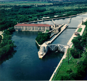
The Chicago Sanitary and Ship Canal, historically known as the Chicago Drainage Canal, is a 32-mile-long canal system that connects the Chicago River to the Des Plaines River. It reverses the direction of the Main Stem and the South Branch of the Chicago River, which now flows out of Lake Michigan rather than into it. The related Calumet-Sag Channel does the same for the Calumet River, 10 miles to the south, joining the Chicago canal about halfway along its route to the Des Plaines River. The two provide the only navigable waterway for ships between the Great Lakes and the Mississippi River system.
The canal was in part built to solve a public health problem. Prior to its opening in 1900, sewage from the city of Chicago was discharged into the Chicago River and flowed into Lake Michigan. The city's drinking water supply was located offshore, and there were fears that the sewage could reach the intake and cause serious disease outbreaks. Since the sewer systems were already flowing into the river, the decision was made to reverse the flow of the river, thereby sending all the sewage inland diluted with lake water, allowing flowing water to assimilate the waste load as it flowed through the canal, Des Plaines River and Illinois River.
Another goal of the construction was to replace the shallow and narrow Illinois and Michigan Canal, which had originally connected Lake Michigan with the Mississippi starting in 1848. As part of the construction of the new canal, the entire route was built to allow much larger ships to navigate it. It is 202 feet wide and 24 feet deep, over three times the size of the I&M. The I&M became a secondary route with the new canal's opening and was shut down entirely with the creation of the Illinois Waterway network in 1933.
The building of the Chicago canal served as intensive and practical training for engineers who later built the Panama Canal. The canal is operated by the Metropolitan Water Reclamation District of Greater Chicago. In 1999, the system was named a Civil Engineering Monument of the Millennium by the American Society of Civil Engineers. The Canal was listed on the National Register of Historic Places on December 20, 2011.

720 m
St. James Catholic Church and Cemetery, also known as St. James at Sag Bridge Church is a historic church and cemetery in the Sag Bridge area of Lemont Township, Illinois. It is situated on a high bluff at the western tip of the glacier-carved Mount Forest Island, overlooking the Calumet Sag Channel and the community of Sag Bridge.
958 m
Palisades is an unincorporated community in Downers Grove Township, DuPage County, Illinois, United States. Palisades is located along the north bank of the Des Plaines River and the Chicago Sanitary and Ship Canal. It is slightly upriver from the larger city of Lemont. Palisades is just east of Waterfall Glen near the Cook County line. It contains a business park on Jeans Road, which includes the Dupage County Knollwood Plant, a water treatment facility, various truck repair facilities, and other businesses. Palisades also contains various houses on the southern end of Madison Street, 97th Street, and Secret Forest Drive. The area is commonly referred to as "The Darien Palisades", given its close proximity to the City of Darien. It is named for Centennial Ridge, a rocky hill between the canal and the river, which reminded early settlers from New Jersey of the New Jersey Palisades. It was originally named Byrneville until 1910.
1.0 km
Sag Bridge, Illinois is an Unincorporated community in Lemont Township in southwestern Cook County, Illinois, United States. Sag Bridge is an important waterway junction between the Calumet Sag Channel and the Chicago Sanitary and Ship Canal. It is also the junction of IL 83 and IL 171 which meet at Sag Bridge to cross the Calumet Sag Channel together on the eponymous bridge. The community was named for a predecessor of the present bridge. It is within the village limits and postal delivery zone of Lemont, Illinois.
Other than the bridge for which it was named and the canal that the bridge crosses, the most significant feature of the community is the historic St. James at Sag Bridge Catholic Church, listed on the National Register of Historic Places.

1.4 km
The Chicago Area Waterway System is a complex of natural and artificial waterways extending through much of the Chicago metropolitan area,
covering approximately 87 miles altogether. It straddles the Chicago Portage and is the sole navigable inland link between the Great Lakes and the Mississippi River and makes up the northern end of the Illinois Waterway.
The CAWS includes various branches of the Chicago and Calumet Rivers, as well as other channels such as the North Shore Channel, Cal-Sag Channel, and Chicago Sanitary & Ship Canal. The CAWS ends near the Lockport Navigational Pool, the highest elevated of the eight pools of the Illinois Waterway. There are three major locks within the CAWS, operated by the Army Corps of Engineers: the Chicago Harbor Lock, the Lockport Lock & Dam, and the T.J. O'Brien Lock and Dam.
Artificial waterways connecting the Mississippi and Great Lakes systems via the Chicago area, over the Chicago Portage, began with the I&M Canal in 1848. The CAWS as it exists today began to take shape in 1900, with the construction of the Chicago Sanitary & Ship Canal to reverse the flow of the Chicago River, which previously flowed into Lake Michigan, so as to instead flow toward the Mississippi River, thus carrying sewage away from the City of Chicago. Thereafter, additional artificial waterways were built that became part of the CAWS, such as the North Shore Channel, which runs inland from Wilmette to the Chicago River and was constructed in 1910, and the Cal Sag Channel, which provides a direct path from the Calumet River to the Illinois Waterway and was finished in 1922.
In the 21st century, a focus of concern around the CAWS has been its potential role as a corridor for Asian carp to enter Lake Michigan. Suits in district court and before the United States Supreme Court have been unable to obtain an injunction requiring the connection between the CAWS and the Mississippi drainage to be closed.