


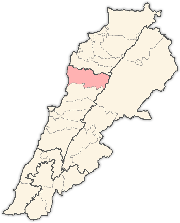
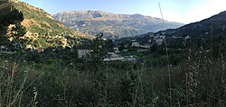
Laqlouq (Arabic: لقلوق), also spelled Laklouk and also known as ′Arab Laqlouq (Arabic: عرب القلوق) is a small mountainous village in mountainous area in the Byblos District of Keserwan-Jbeil Governorate, Lebanon. It is located 69 kilometers northeast of Beirut. Laqlouq has an average elevation of 1,780 meters above sea level and a total land area of 210 hectares.
Gallery


Sponsored
Location
1 explorer visited this place

3.9 km
The Baatara gorge sinkhole is a waterfall in the Batroun district of Lebanon near the village of Chatine in the town of Tannourine.
The waterfall drops 255 metres into the Balaa Pothole, a cave of Jurassic limestone located on the Lebanon Mountain Trail. The cave is also known as the Cave of the Three Bridges. Traveling from Laklouk to Tannourine one passes the village of Balaa, and the Three Bridges Chasm is a five-minute journey into the valley below where one sees three natural bridges, rising one above the other and overhanging a chasm descending into Mount Lebanon. During the spring melt, a 90–100-metre cascade falls behind the three bridges and then down into the 240-metre chasm.
Discovered to the western world in 1952 by French bio-speleologist Henri Coiffait, the waterfall and accompanying sinkhole were fully mapped in the 1980s by the Spéléo club du Liban. A 1988 fluorescent dye test demonstrated that the water emerged at the spring of Dalleh in Mgharet al-Ghaouaghir.
4.0 km
Mazraat es-Siyad is a village and municipality in the highlands of the Byblos District in the Keserwan-Jbeil Governorate, Lebanon. The town is 58 kilometres away from Beirut, and stands at an elevation of 1,250 m above sea level.

4.7 km
Mghayreh is a municipality in the Byblos District of Keserwan-Jbeil Governorate, Lebanon. It is 82 kilometers north of Beirut. Mghayreh has an average elevation of 1,300 meters above sea level and a total land area of 263 hectares. Its inhabitants are predominantly Maronite Catholics and Shia Muslims. It's situated on the slopes of Joubbat El Mnaitra and is bordered by Aqoura to the south, Afqa to the west and Qartaba to the east.

4.8 km
Qartaba is a town in the mountains of the Byblos District of the Keserwan-Jbeil Governorate, Lebanon. It is located 57 kilometers north Beirut on the mountains above Byblos at an average altitude of 1,250 meters. It is the second-most populous city in the district after Byblos.
Qartaba extends between the municipal borders of Almat el Jnoubiye to the northwest, Balhoss to the west, Qorqaiya to the southwest, Janne to the south, Deir Mar Sarkis to the east, and Mazraat es-Siyad to the northeast. It stands as one of the largest and most prominent towns in the Byblos District, renowned for its role as a premier resort and a major tourist destination. It offers a unique appeal with its dry, mild climate, making it an ideal spot for visitors year-round.
Book your tour near
Laqlouq
→
Most of the inhabitants are Maronite christians, similar to the majority of Byblos District's population, which is largely Maronite Christian with a significant Shia Muslim minority.