
 English
 Français
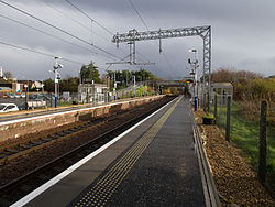
Stepps railway station
Stepps railway station serves the town of Stepps, North Lanarkshire, Scotland. The railway station is located on the Cumbernauld Line, 5¼ miles (8 km) north east of Glasgow Queen Street (High Level) and is managed by ScotRail.
Nearby Places View Menu

299 m
Cardowan
Cardowan is a suburb situated in North Lanarkshire, Scotland, on the north-eastern outskirts of Glasgow.
Originally built around Cardowan Colliery, Garnkirk fire-clay works and clay mines in the immediate area, Cardowan's proximity to Glasgow has been key to its expansion over the years, which has seen the former colliery site being transformed into a large scale residential development.

727 m
Stepps
Stepps (Scottish Gaelic: Ceumannan) is a town in North Lanarkshire, Scotland, near the north-eastern outskirts of Glasgow. According to data gathered by North Lanarkshire Council in 2020, Stepps is estimated to have a population of roughly 7,700 inhabitants. Its recently upgraded amenities include a new primary school, library and sports facilities.
The town retains a historic heart around its church in Whitehill Avenue, whilst examples of Victorian and Edwardian housing can still be found. The travel connections by road and rail mean residents work in Glasgow, Edinburgh, Falkirk, Stirling and beyond. The town is located in close proximity to the new Seven Lochs Wetland Park, from which views to the Campsies and Loch Lomond can be enjoyed.

848 m
Molendinar Burn
The Molendinar Burn is a small tributary of the Clyde in Glasgow, Scotland, now largely culverted. It is popularly associated with Saint Mungo, who is said to have founded his church on its banks. The name may stem from Mellingdenor, a place mentioned in Jocelin of Furness's biography of Mungo. The further etymology of the name is obscure; the first element may be Cumbric melin, meaning "mill".

1.6 km
Millerston
Millerston is a district partially in the Scottish city of Glasgow and partially in North Lanarkshire. It is situated north of the River Clyde, to the north of the city's Craigend, Garthamlock and Ruchazie neighbourhoods, but physically separated from them by parkland and wooded areas. It is also home to the playing fields of Glasgow's St Aloysius College and Strathclyde University.
Whilst part of Millerston belongs to Glasgow City Council, the other part is served by North Lanarkshire Council. The official Millerston boundary starts at Hogganfield Loch stretching all the way down Cumbernauld Road as far as Laundry Lane but in recent times, the area has been incorporated into the larger town of Stepps which is entirely within North Lanarkshire.
Millerston enjoys a convenient location due to its close proximity to Glasgow City Centre and has been identified as one of the growth areas for Glasgow City Council. A train station (at Robroyston, with a new road connecting Millerston to the suburb of that name - they were previously separated by fields) is in the pipeline as are many new homes and businesses. The area has countryside on the doorstep along with many pleasant places to walk locally such as Hogganfield Park.
Millerston sits between the M8 and M80 motorway networks, making it popular for commuting throughout the Central Belt. The new railway station approach road will also allow access to Junction 2 of the M80, a quicker connection for local residents who currently must travel through Stepps to Junction 3; however, this may also increase traffic in the area. There are two public houses in Millerston, The Dug and Duck and The Real MacKay. The district is also home to a fish and chip shop, a curry house, a Chinese take-away, a convenience store, a post office and a small church, Millerston United Free Church of Scotland.