
 English
 Français

Bataille de la passe de Brander
La bataille de la passe de Brander opposa le roi d'Écosse Robert Ier à ses rivaux du clan MacDougall en juillet ou août 1308 près du Loch Awe dans le Lorne. Elle se solde par la défaite des MacDougall, qui sont définitivement vaincus et contraints à l'exil.
Nearby Places View Menu
83 m
Battle of the Pass of Brander
The Battle of the Pass of Brander in Scotland forms a small part of the wider struggle known as the Wars of Scottish Independence, and a large part of the civil war between the Bruce and Balliol factions, a parallel and overlapping conflict. It was a victory for King Robert the Bruce over the MacDougalls of Argyll, kinsmen of John Comyn, also known as the Red Comyn, who had been killed by Bruce and his adherents at Dumfries in 1306. The sources do not allow us to determine the date of the battle with any degree of precision: various dates between 1308 and 1309 have been suggested, though the late summer of 1308 would seem to be the most likely. Traquair dates it to August 1308.

3.1 km
Pass of Brander stone signals
The Pass of Brander stone signals, also known as Anderson's Piano, are a series of railway signals that are automatically triggered by rockfalls. They are located in the Pass of Brander, between Loch Awe and Taynuilt stations on the Oban branch of the West Highland Line in Scotland.
A screen of wires, linked to semaphore signals, is erected on the mountainside alongside the railway track. In the event of one or more wires being broken, signals in each direction are automatically placed at 'danger'. They are part of a warning system that advises train drivers to exercise caution in the event of a rock-fall, and cover a section of track that is just over 4 miles (6.4 km) in length.

3.3 km
Pass of Brander
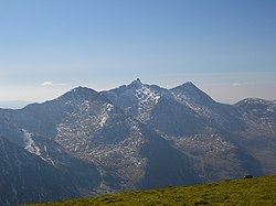
The Pass of Brander is a mountain pass in the Highlands of Scotland, where the main railway and road to Oban makes its way between Cruachan, a 3,689-foot (1,124 m) mountain, and Loch Awe.
A conventional turbine power station was created by damming the River Awe in the Pass of Brander, feeding the water through underground pipes, and generating electricity as it flows into Loch Etive.
It is notable for the Battle of the Pass of Brander, an important victory by Robert the Bruce, and the Pass of Brander stone signals, known as Anderson's Piano, alongside the railway line, to guard against rockfalls.
3.3 km
Ben Cruachan
Ben Cruachan (Scottish Gaelic: Cruachan Beann) is a mountain that rises to 1,126 metres (3,694 ft), the highest in Argyll and Bute, Scotland. It gives its name to the Cruachan Dam, a pumped-storage hydroelectric power station located in a cavern inside the mountain. It is the high point of a ring of mountains, known as the Cruachan Horseshoe, that surrounds the power station reservoir. The horseshoe includes a further Munro (Stob Diamh), a Corbett (Beinn a' Bhuiridh), and several subsidiary summits. "Cruachan!" is the battle cry of Highland clans Campbell and MacIntyre.

4.3 km
Cruachan Power Station
The Cruachan Power Station (also known as the Cruachan Dam) is a pumped-storage hydroelectric power station in Argyll and Bute, Scotland, UK. The scheme can provide 440 MW of power and produced 705 GWh in 2009.
The turbine hall is located inside Ben Cruachan, and the scheme moves water between Cruachan Reservoir and Loch Awe, a height difference of 396 m (1,299 ft). It is one of only four pumped storage power stations in the United Kingdom, and is capable of providing a black start capability to the National Grid.
Construction began in 1959 to coincide with the Hunterston A nuclear power station in Ayrshire. Cruachan uses cheap electricity generated at night to pump water to the higher reservoir, which can then be released during the day to provide power as necessary. The power station is open to visitors, and around 50,000 tourists visit it each year.