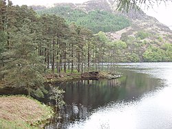
Glentrool is a collection of mountain biking routes through the heart of Galloway in southwest Scotland. The mountain bike routes are part of the 7Stanes project by Forestry and Land Scotland throughout the Scottish Borders and Dumfries and Galloway. The most famous route at Glentrool is the 'Big Country' trail, based entirely on minor public roads and forest roads. The trail follows 58 km (36 mi) of road in a loop, starting and finishing at the Glentrool visitor centre. There are areas of off-road biking allowing riders of all experiences and age ranges to have a good time. In early 2007 the Forestry Commission built a blue graded route which is 8 km (5 mi) long and follows purpose built singletrack in a loop from the visitor centre to Loch Trool and finishes back at the visitor centre. Car parking and toilet facilities are available at the visitor centre also has a cafe with seasonal opening times from April to September.

Nearby Places View Menu
Location Image
2.8 km

Glen Trool

Glentrool (Scottish Gaelic: Gleann an t-Sruthail) is a glen in the Southern Uplands, Galloway, Scotland. It contains Loch Trool which is fed by several burns and drained by the Water of Trool. North of Glen Trool is Merrick, the highest mountain in the Southern Uplands. The glen has a visitors centre and campsite. In April 1307 it was the site of the Battle of Glen Trool.
Location Image
3.4 km

Bargrennan

Bargrennan (Scottish Gaelic: Bar Grianain, meaning height of the summer house or sunny spot) is a village in Dumfries and Galloway, in the south west of Scotland. It is located 9 miles northwest of Newton Stewart by the River Cree and on the A714 road to Girvan. The Southern Upland Way runs through the village and the Glentrool Forest, managed by the Forestry Commission, is to the north-east of the village. White Cairn, Bargrennan gives its name to the class of prehistoric monuments known as Bargrennan chambered cairns.
Location Image
4.1 km

Loch Trool

Loch Trool is a narrow, freshwater loch in Galloway, in the Southern Uplands in south-west Scotland. It lies in an elevated position in Glen Trool in the Galloway Forest Park and is approximately 8 miles (13 km) north of the town of Newton Stewart. The loch is the source of the Water of Trool which flows to the Water of Minnoch and the River Cree. There is a walking trail and footpath around the loch's perimeter. In April 1307 Robert the Bruce fought and won the Battle of Glen Trool on the shores of the loch. On its north side stands Bruce's Stone which commemorates the victory. Loch Trool is also reported to be the darkest place in the UK at night.
Location Image
4.3 km

Silver Flowe-Merrick Kells

Situated in south-west Scotland, the Silver Flowe-Merrick Kells biosphere reserve is composed of two separate sites. Silver Flowe is a unique bog formation and one of the least interrupted undisturbed mire systems in Europe. Its high value is principally due to the landscape pattern of an assemblage of discrete mires. It is also a breeding site for the rare Azure Hawker dragonfly. Silver Flowe is also designated as Ramsar site. Merrick Kells contains three habitats of European interest: blanket bog, montane acid grasslands, and wet heath with cross-leaved heath. There are mires supporting various communities, and the area has a wide variety of species but low population levels. There are nationally important breeding bird populations, and important invertebrate populations. The site is the largest remaining unafforested area of upland in Galloway. Both sites are surrounded by commercial coniferous forestry. The management of Merrick Kells and Silver Flowe is mainly carried out through non-intervention, apart from areas where extensive livestock grazing is practised in order to manage vegetation. Proposals made in the periodic review for extending this reserve to meet the Seville criteria are being considered.