
 English
 Français
Hell's Glen
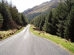
Hell's Glen is a glen in Argyll and Bute, Scotland, within the Arrochar Alps. The B839 single-track road passes through the glen. To the west, the glen leads to Loch Fyne and to the east Lochgoilhead. Glen Mhor (B828) joins the glen about half way along and leads to Glen Croe at the Rest & be Thankful viewpoint. The glen is named from its name in Gaelic, Glen Iarainn. This means "the Iron Glen" but sounds like the nearby Glen Ifhrinn which means "the Glen of Hell." The glen is also known as An Gleann Beag, "the small glen", in Scottish Gaelic. The glen is within the Argyll Forest Park that is itself within the Loch Lomond and The Trossachs National Park.
Nearby Places View Menu

1.1 km
Cruach nam Mult
Cruach nam Mult is a mountain in the Arrochar Alps, Argyll, Scotland which lies to the southern side of Hell's Glen. The mountain is near Loch Fyne and GlenGoil and is part of the northern side of the area of the Arrochar Alps that follow south to Loch Goil.

1.4 km

2.5 km
The Tinkers' Heart
The Tinkers' Heart is a Scottish Travellers' commemorative monument near the village of Cairndow by Loch Fyne in Argyll and Bute, Scotland. It is also known as the Gypsy's Heart, Gypsies' Heart or Gypsy's Wedding Heart. It is scheduled as a Monument of National Importance.
A field visit in 2012 shows the Heart as being made up of a heart-shape of 25 visible quartz pebbles, with a 26th pebble in the centre, and measuring 1.75 metres (5.7 ft) by 1.4 metres (4.6 ft). Research done by Historic Scotland in 2015 concluded that from the evidence available, it was the only example in Scotland of a permanent physical Scottish Travellers' memorial.
3.2 km
Mullach Coire a' Chuir
Mullach Coire a' Chuir is a 640m rugged mountain near Lochgoilhead in Argyll, Scotland and forms part of the well known Arrochar Alps range. It lies to the west of Glen Goil and is visible from Lochgoilhead.