


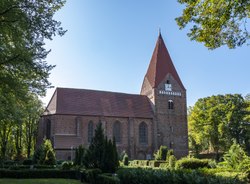
Le phare de Timmendorf (en allemand : Leuchtturm Timmendorf) est un phare actif situé sur l'île de Poel, près du village de Timmendorf, dans l'Arrondissement du Mecklembourg-du-Nord-Ouest (Mecklembourg-Poméranie-Occidentale), en Allemagne. Il est géré par la WSV de Lübeck .
Book your tour near
Phare de Timmendorf
Book Now
4.3
in partnership with
GetYourGuide.com
Gallery


Sponsored
Location

939 m
Timmendorf is part of the municipality of Insel Poel on the Baltic Sea island of the same name in the district of Nordwestmecklenburg in the German state of Mecklenburg-Vorpommern. Timmendorf lies on the west coast of the island of Poel and is divided into the villages of Timmendorf and Timmendorf Strand, which are about a kilometre from one another. A prominent landmark in Timmendorf Strand and sea mark for the navigation of shipping in the Bay of Wismar is Timmendorf Lighthouse. A little to the north of the lighthouse there is a pilot's house with a tower. The settlement has a one-kilometre-long sandy beach and a small harbour in which sports boats, fishing vessels and a pilot boat are moored. The tourist infrastructure includes various holiday apartments, a large campsite and several restaurants. In summer the beach of Timmendorf Strand is packed with visiting bathers and the harbour of Timmendorf is full of yachts.
3.8 km
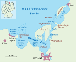
Poel or Poel Island, is an island in the Baltic Sea. It forms the natural northern and eastern boundaries of the Bay of Wismar on the German coast. The northern coast of the island is also on the south side of the large gulf known as the Bay of Mecklenburg, which Wismar Bay enters into. Insel Poel thus forms on its northern side the unofficial latitude of the northern boundary of the Wismar Bay.
It is close to the cities of Lübeck, Wismar and Schwerin and is part of the Hamburg Metropolitan Region.
Administratively it is a municipality in the Nordwestmecklenburg district. It consists of Kirchdorf and Oertzenhof and the smaller villages of Timmendorf, Wangern, Hinterwangern, Weitendorf, Weitendorf-Hof, Brandenhusen, Neuhof, Seedorf, Niendorf, Schwarzer Busch, Kaltenhof, Fährdorf, Malchow, Vorwerk and Gollwitz. It covers an area of 36.02 km2 and has 2,873 citizens. Satellite pictures show that most of it is used as farmland. With its good air, clean water, fine beaches and sheltered harbours, it is also popular recreational area. At Timmendorf harbour there are a pilot's station and facilities for yachts and local fishermen. Kirchdorf has a yachting harbour and a boatyard. Wismar Bay is cited by the Encyclopædia Britannica Eleventh Edition as the finest harbor on the Baltic.
The island's name derives from pole, the Common Slavic word for "flat land" or "field".

3.8 km
Kirchsee, near the island of Poel, is part of Wismar Bay in Mecklenburg-Vorpommern, Germany. The bay cuts deeply into the island of Poel from the south.
It is named after the main town on the island of Poel, Kirchdorf. The bay is approximately three kilometers long and up to one kilometer wide at its southern end. The southern opening is formed by the two sand spits, Fährdorfer Haken and Brandenhusener Haken, which were created by wind and currents. The shores of the Kirchsee are very diverse, alternating between cliff coasts, flat sandy shores, and smaller alluvial areas. Kirchsee is a shallow body of water, mostly less than two meters deep. Only the navigation channel leading to the port of Kirchdorf is deeper. Maintaining the navigation channel also ensures Kirchsee’s access to the sea, as this access would otherwise silt up.
5.3 km
The Bay of Wismar or more commonly Wismar Bay or Wismarbucht is a well sheltered multi-sectioned bay in the southwestern Baltic Sea, in Mecklenburg-Vorpommern, Germany, and is considered the south-central part of the much larger arm of the Baltic known as the Mecklenburg Bay—a long fingerlike gulf oriented to the west-southwest from the Baltic proper. Wismar bay is considered one of the finest natural harbors on the Baltic, and served as the destination for much seaborne shipping until circa the 1910s when its minimum depths of 5 meters became too shallow for larger more modern ships. Today, because of the shallow sheltered waters the bay is the subject of much research via underwater archeology.
There are four lobe like parts of the Bay of Wismar which are themselves bays on its southern shores, each separated by a north intruding headland from the others and a broad channel running northwest to southeast parallel to the line formed by the tips of the four bounding headlands. The tips of the four headlands are remarkably well aligned and very closely co-linear spanning 10.80 mi northwest to southeast tip to tip along the channel along which the inlets are respectively Boltenhagen Bay, Wohlenberger Wiek, Eggers Wiek, and the inner bay. A channel, the Breitling between Poel island and the mainland is accounted part of the bay as well, which in its northern limit is the north shore of the island.
From the western headland to the eastern shore of the inner bay is 13.4 miles. All of the waters are bounded by Poel Island on one side—a large mainly agricultural and recreational island sheltering the most easterly parts of bay along most of its northern edge.
The sheltered anchorage extends over a rhombus shaped area in the southerly lee of Poel island roughly 3 miles N–S in the inner anchorage narrowing to 1.75 miles N-S between the innermost headland and southernmost tip of the island and roughly 5–6 miles that distance WNW to ESE.
In general, the main waters of the bay are located to the west, southwest and south relative to Poel Island which is wholly within Wismar Bay. The northern tip of the island in a line westerly to the headland of Großklützhöved north of the village of Klütz) forms the mouth of the bay.
Main ports: Wismar, 20 mi by rail north of Schwerin.
5.3 km
Eggers Wiek is a sickle-shaped bay within the Bay of Wismar on the southwestern Baltic Sea coast of the German state of Mecklenburg. Its stretch of beach lies about six kilometres northwest of the Hanseatic town of Wismar and is about five kilometres long. The coast here is steep in places with sea cliffs up to 11 m above sea level, but in the middle it also has flat, sandy beaches. Opposite the Wiek lies the island of Poel, about 3.5 kilometres away. Eggers Wiek is bordered to the northwest by the stony cape of the Hohe Wieschendorfer Huk. West of this hook, the larger bay of Wohlenberger Wiek opens up. The coastal section of Eggers Wiek belongs to the parishes of Hohenkirchen and Zierow in the district of Nordwestmecklenburg. In Hohes Wieschendorf in the municipality of Hohenkirchen, the landing stage has been expanded into a marina which, along with a golf course on the cape, contributes to the development of tourism in the area.
Book your tour near
Phare de Timmendorf
Book Now
4.3
in partnership with
GetYourGuide.com