


Huntington is a town in Hampshire County, Massachusetts, United States. The population was 2,094 at the 2020 census. It is part of the Springfield, Massachusetts Metropolitan Statistical Area. The main village of Huntington is in the south of the town, with the villages of Norwich and Norwich Bridge in the center.
Book your tour near
Huntington, Massachusetts
Book Now
4.4
in partnership with
GetYourGuide.com
Gallery


Sponsored
Location
1 explorer visited this place

398 m
Huntington is a census-designated place comprising the main village in the town of Huntington in Hampshire County, Massachusetts, United States. The population of the CDP was 936 at the 2010 census, out of a total town population of 2,180. It is part of the Springfield, Massachusetts Metropolitan Statistical Area.
444 m
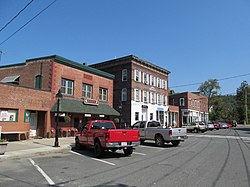
The Huntington Village Historic District encompasses the historic village center of Huntington, Massachusetts, USA. The village lies on the west branch of the Westfield River, at the junction of US Route 20 and Massachusetts Route 112. The district was listed on the National Register of Historic Places in 1999. The village is the most densely populated part of Huntington, and has been its commercial and civic heart since the early 19th century. It has been divided by the river because its unifying feature, a location where bridges stood since 1810, no longer has one, and the modern replacement bridge built after a 1938 flood just south of the center, does not readily combine the developed areas on either side.
Most of the district was built up between the middle 19th and middle 20th centuries. The area was home to several textile mills, powered by the Westfield River, but none of which have survived. Most of the district's contributing properties are therefore residential, commercial, and civic, and represent a diversity of architectural styles, predominantly from the mid to late 19th century. The district includes properties along the two main roads, as well as Upper Russell, Basket, Laurel, Pleasant, and Park Streets. Of particular architectural note are a concentration of Greek Revival houses characterized by their temple fronts, found in the western part of the village, and Stanton Hall, a fine Italianate structure built as a church, but now owned by the town.
2.4 km
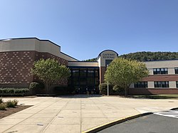
Gateway Regional High School, commonly referred to as "Gateway" or "Gateway Regional," is a public high school located in Huntington, Massachusetts, United States. It is the only high school in the Gateway Regional School District, serving students from Blandford, Chester, Huntington, Middlefield, Montgomery, and Russell.

3.2 km
Littleville Lake is located mostly in the town of Chester in Hampden County and partly in the town of Huntington in Hampshire County, Massachusetts. It was created by the US Army Corps of Engineers when the Middle Branch of the Westfield River was dammed to control flooding.

4.4 km
C. M. Gardner State Park is a Massachusetts state park, located in the town of Huntington, along a section of the east branch of the Westfield River. The land was donated to the state in 1959, in memory of Charles M. Gardner, a local farmer, writer, and National Grange leader. It is managed by the Department of Conservation and Recreation.
Book your tour near
Huntington, Massachusetts
→
(The villages are unofficial neighborhoods representing clusters of buildings in an otherwise rural town.) The villages of Knightville (or Knightsville) and Indian Hollow toward the north were removed by the construction of the Knightville Dam from 1939 to 1941.