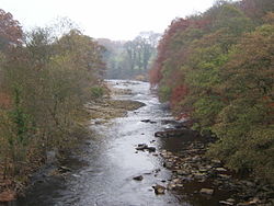
North Yorkshire is a ceremonial county in Northern England. It is bordered by County Durham to the north, the North Sea to the east, the East Riding of Yorkshire to the south-east, South Yorkshire to the south, West Yorkshire to the south-west, and Cumbria and Lancashire to the west. The county is the largest in England by land area, at 8,654 km2 (3,341 sq mi), and had a population of 1,201,415 in 2024. Middlesbrough and Redcar are located in the north-east of the county and form part of the Teesside conurbation, which extends into County Durham. The city of York is located in the south. The remainder of the county is rural, and its settlements include Harrogate in the south-west, the city of Ripon near the centre, and Scarborough on the coast in the east. For local government purposes the county comprises the unitary authority areas of North Yorkshire, Middlesbrough, Redcar and Cleveland, York, and part of Stockton-on-Tees. The local authorities of York and North Yorkshire form a combined authority of the same name, and the local authorities of the other three areas are part of the Tees Valley Combined Authority. The county was historically part of Yorkshire. The centre of the county contains a wide plain, called the Vale of Mowbray in the north and Vale of York in the south. The North York Moors uplands lie to the east, and south of them the Vale of Pickering is separated from the main plain by the Howardian Hills. Further east, the county has a coastline on the North Sea. The west of the county contains the Yorkshire Dales, an extensive upland area which contains the source of the River Ouse/Ure and many of its tributaries, which together drain most of the county before reaching the Humber estuary in the south. The Dales also contain the county's highest point, Whernside, at 2,415 feet (736 m).

Lieux à Proximité Voir Menu
Location Image
564 m

Ellenthorpe

Ellenthorpe is a civil parish in the county of North Yorkshire, England. In 2001, the civil parish had 34 inhabitants. It was mentioned in the Domesday Book (1086) as Adelingestorp. From 1974 to 2023 it was part of the Borough of Harrogate, it is now administered by the unitary North Yorkshire Council.
769 m

Battle of Myton

The Battle of Myton, nicknamed the Chapter of Myton or The White Battle because of the number of clergy involved, was a major engagement in the First Scottish War of Independence, fought in Yorkshire on 20 September 1319.
Location Image
1.2 km

Myton Bridge

Myton Bridge is a historic structure in Myton-on-Swale, a village in North Yorkshire, in England. A bridge over the River Swale in Myton was first recorded in the early 12th century, but it was demolished later in the century, and a replacement not built until 1313. It was a scene of fighting during the Battle of Myton, and had collapsed by 1354. In 1868, a new bridge was constructed at the same location, on the initiative of Henry Miles Stapylton. It has three arches, the central one, 100 feet (30 m) wide, for the river, and the others, each 24 feet (7.3 m) wide, for floodwater. The structure was designed by G. Gordon Page, under the supervision of his father, Thomas Page. The bridge was grade II listed in 1991, and was restored in 2002. The bridge is constructed cast iron, and consists of a shallow triple arch with openwork spandrels, and circular panels containing shields, each decorated with a lion in relief. There are iron cross-girders, and an octagonal patterned iron balustrade with a handrail. The abutments are in red brick with stone dressings and have corner piers, those on the river side with chamfered plinths, bracketed cornices and pyramidal caps. Outside them are brick parapet walls with stone coping on brackets, and at the end are shorter piers.
Location Image
1.4 km

River Swale

The River Swale in Yorkshire, England, is a major tributary of the River Ure, which becomes the River Ouse, that empties into the North Sea via the Humber Estuary. The river gives its name to Swaledale, the valley through which it flows. The river and its valley are home to many types of flora and fauna typical to the Yorkshire Dales. Like similar rivers in the region, the river carves through several types of rock and has features typical of both river and glacial erosion. The River Swale has been a contributory factor in the settlements that have been recorded throughout its history. It has provided water to aid in the raising of crops and livestock, but also in the various mining activities that have occurred since Roman times and before. The river is said to be the fastest flowing in England and its levels have been known to rise 10 feet (3 m) in 20 minutes. Annual rainfall figures average 1800 mm p.a. in the headwaters and 1300 mm p.a. in the lower waters over a drop of 148 m in 32 km.