
 English
 Français

Parton, Dumfries and Galloway
Parton is a hamlet situated on the banks of the River Dee in the historical county of Kirkcudbrightshire, Dumfries and Galloway, Scotland.
Nearby Places View Menu

346 m
Parton railway station (Portpatrick and Wigtownshire Joint Railway)
Parton railway station served the hamlet of Parton, in the historic county of Kirkcudbrightshire in the administrative area of Dumfries and Galloway, Scotland, from 1861 to 1965 on the Portpatrick and Wigtownshire Joint Railway.

900 m
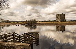
Loch Ken
Loch Ken is a 9 miles (14 km) long freshwater loch in the historic county of Kirkcudbrightshire in Dumfries and Galloway, Scotland. It lies in the Glenkens, where it is fed from the north by the Water of Ken and from the west by the Dee. It continues as the Dee south from Glenlochar, where the water is held back by the Glenlochar Barrage. Part of the Galloway hydro-electric power scheme, the barrage regulates the river's flow.
1.9 km
Airds of Kells
Airds of Kells is a farm and a small estate in the historical county of Kirkcudbrightshire in the parish of Kells, Dumfries and Galloway, Scotland. The Category B listed farmhouse dates from the late 18th century but possibly incorporates parts of an older building. The estate was associated with the Gordons of Lochinvar from the 15th century.
Airds of Kells Wood is a biological Site of Special Scientific Interest, notified in 1983. It has the largest remaining block of oak woodland in the Water of Ken/River Dee valley.
2.8 km
Kirkcudbrightshire
Kirkcudbrightshire ( kur-KOO-bree-shər), also known as the County of Kirkcudbright or the Stewartry of Kirkcudbright, is one of the historic counties of Scotland, located in the southwest of the country.
Until 1975, Kirkcudbrightshire functioned as an administrative county for local government purposes. Since then, its territory has formed part of the Dumfries and Galloway council area. The name continues to be used for certain ceremonial and legal purposes: it remains a registration county for land registration, and from 1975 to 1996 a lower-tier district known as the Stewartry covered most of the historic county. The same boundaries are still used today for the lieutenancy area of the Stewartry, and the Dumfries and Galloway Council maintains a Stewartry area committee.
Historically, Kirkcudbrightshire formed the eastern portion of the medieval Lordship of Galloway, which retained a measure of autonomy until its full incorporation into the Kingdom of Scotland during the 13th century. In 1369, the area east of the River Cree was placed under the jurisdiction of a steward based in Kirkcudbright, from which it derived the name "Stewartry of Kirkcudbright." The remainder of Galloway was administered by a sheriff seated in Wigtown, giving rise to the county of Wigtownshire. Kirkcudbrightshire was occasionally referred to as "East Galloway."
The county is bounded to the north by Ayrshire, to the west by Wigtownshire, to the south by the Irish Sea and the Solway Firth, and to the east by Dumfriesshire. Its county town is Kirkcudbright.