
 English
 Français

Sandsend railway station
Sandsend railway station was a railway station on the Whitby, Redcar and Middlesbrough Union Railway. It was opened on 3 December 1883, and served the villages of Sandsend and Lythe. It closed on 5 May 1958. The station building is now a private residence. It was the only station between Whitby and Loftus not to possess a passing loop.
Nearby Places View Menu
525 m
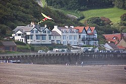
Sandsend
Sandsend is a small fishing village, near to Whitby in North Yorkshire, England. It forms part of the civil parish of Lythe. It is the birthplace of fishing magnate George Pyman. Originally two villages, Sandsend and East Row, the united Sandsend has a pub and restaurant. A large part of the western side of the village, in The Valley, is still owned by the Mulgrave Estate. The Valley is one of the most expensive areas to buy property on the Yorkshire Coast.

952 m
Sandsend Ness
Sandsend Ness is an old alum quarrying site close to Whitby in North Yorkshire, England.
Beneath extensive deposits of grey pyritic shale a thin band of sideritic mudstone is present at this site and there is a further 6 metres (20 ft) of almost non-bituminous shale beneath it. This geological configuration, along with its proximity to the port of Whitby, offered Sandsend near-ideal conditions for the rapidly expanding alum industry from the early 17th century onwards.
So wide-scale and prolonged were these activities, that significant areas of the Yorkshire coast were permanently altered.
The double sulphate of aluminium and either potassium or ammonia is commonly known as alum. This material was of great importance through to the late 19th century in leather tanning and in the wool dying industry. Even today it is still used in some places as a mordant (dye fixative).
Fossils are present in large numbers in the deposits, including ammonites such as Hildoceras bifrons and Dactylioceras bifrons and also Ichthyosaur and Plesiosaur remains, though the latter are nowadays much less commonly found. In fact, the ammonite Hildoceras is named after an early Christian saint, the Abbess of Whitby St. Hild or Hilda (614–680). It was believed that such ammonite fossils were the snakes which had been miraculously turned into stone by St. Hilda. It was not unknown for local "artisans" to carve snakes' heads onto ammonites, and sell these "relics" as proof of the miracle. The coat of arms of nearby Whitby actually include three such 'snakestones'.

967 m
Church of St Oswald, Lythe
The Church of St Oswald, Lythe, is the parish church for the village of Lythe, 4 miles (6.4 km) west, north west of Whitby in North Yorkshire, England. The church is at the top of Lythe Bank (the western end) and is just east of the village on the A174 road.
A church has been on the site since the 13th century, though the present building was adapted from the old church in 1910 by Sir Walter Tapper. It was grade I listed in 1969.

1.3 km
Lythe
Lythe is a small village and large civil parish, in North Yorkshire, England, situated near Whitby within the North York Moors National Park. The name of the village derives from Old Norse and means hill or slope.
It was in the old North Riding and in the wapentake of Langbaurgh East until 1974. From 1974 to 2023 it was part of the Borough of Scarborough. It is now administered by the unitary North Yorkshire Council.
According to the 2011 UK census, Lythe parish had a population of 377, a reduction on the 2001 UK census figure of 465.