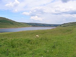
Stonebeck Up is a civil parish in the county of North Yorkshire, England. The only village in the parish is Middlesmoor. The population of the parish in the 2011 census was 119. The parish occupies the highest part of Nidderdale. It is bounded on the south side by Stean Beck, from which the parish takes its name (stean being a dialect form of "stone"), and which separates it from the parish of Stonebeck Down. To the west and north it is bounded by a ridge, including the summits of Great Whernside and Little Whernside, and to the east it is bounded by Masham Moor, a ditch known as Mere Dike, and the River Nidd. The parish includes Angram and Scar House Reservoirs, and large areas of grouse moor. Historically Stonebeck Up was a township in the ancient parish of Kirkby Malzeard in the West Riding of Yorkshire. In the Middle Ages it formed part of the lands of Byland Abbey, which established granges at Middlesmoor, Newhouses, Woodale, Lodge, Angram, Haden Carr and Scar House. The granges survived as farming communities into the twentieth century. Angram and Haden Carr were submerged by the reservoirs, and Lodge was abandoned when Scar House Reservoir was constructed in the 1920s. Stonebeck Up became a separate civil parish in 1866, and was transferred from the West Riding to North Yorkshire in 1974. The parish now shares the Upper Nidderdale grouped parish council with the parishes of Stonebeck Down and Fountains Earth. From 1974 to 2023 it was part of the Borough of Harrogate, it is now administered by the unitary North Yorkshire Council.

Nearby Places View Menu
Location Image
2.1 km

Nidd Valley Light Railway

Nidd Valley Light Railway was a light railway in upper Nidderdale in the West Riding of Yorkshire, England. It was owned by Bradford Corporation Waterworks Department and the corporation also operated its public passenger services. Power & Traction Ltd of London obtained a Light Railway Order for the 6.5-mile (10.5 km) railway from Pateley Bridge to Lofthouse in 1900, but these powers were taken over by Bradford Corporation. A contract to build Angram Reservoir was awarded to John Best & Son in 1903, and he also won the contract to build the public railway and a 6.5-mile (10.5 km) private extension to the reservoir site. This was initially built to 3 ft (914 mm) gauge but was converted to standard gauge by 1907, when the public railway opened. Best had his own locomotives, and Bradford Corporation equipped the public railway with second hand locomotives and carriages from the Metropolitan Railway. The Angram Reservoir project was completed in 1916. The corporation had obtained powers to build another reservoir at Scar House in 1913, and in 1920 decided to proceed, using direct labour rather than a contractor. The railway was upgraded, with the purchase of new and second hand locomotives, a railmotor for the public services, and second hand carriages for the workmen's trains. Curves on the line above Lofthouse were eased, and a short tunnel was built. At its height, the corporation were running fourteen locomotives, three steam navvies and 19 or 20 steam cranes. The work was essentially completed by 1931, but filling of the reservoir did not begin until 1935 and the official opening was the following year. With the work complete, the railway was lifted, and a sale was held at Pateley Bridge. Scar Village, which at its peak had housed 1,135 people, of whom 780 worked on the project, was reduced to eight occupied houses by 1936, with seven pupils at the school. The railway workers were not entitled to a pension, but pensions were awarded to four men who had served for many years.
Location Image
2.1 km

Angram Reservoir

Angram Reservoir is the first of three reservoirs on the River Nidd in Upper Nidderdale, North Yorkshire, England, the others being Scar House Reservoir and finally the compensation reservoir Gouthwaite Reservoir. It is located at OS map reference SE040759. Between them they attract around 150,000 visitors a year. The reservoir takes its name from Angram, a settlement in the township of Stonebeck Up, submerged when the reservoir was completed in 1919. Little Whernside (604 metres [1,982 ft]) to the north and Great Whernside (704 metres [2,310 ft]) to the west of the reservoir are close by. The River Nidd flows for approximately 2 miles (3 km) from the flanks of Great Whernside before joining the reservoir.
Location Image
2.4 km

Nidd Aqueduct

The Nidd Aqueduct is an aqueduct or man-made watercourse in North Yorkshire, England. It feeds water from Angram and Scar House reservoirs in upper Nidderdale, North Yorkshire 32 mi (51 km) to Bradford in West Yorkshire. The aqueduct supplies 21,000,000 imp gal (95,000 m3) of water per day to Chellow Heights water treatment works. The aqueduct and the reservoirs it connects to are all maintained by Yorkshire Water.
Location Image
2.4 km

Scar House Reservoir

Scar House Reservoir is the second of the three reservoirs in Upper Nidderdale, North Yorkshire, England, the others are Angram Reservoir and Gouthwaite Reservoir. Between them they attract around 150,000 visitors a year. Angram and Scar House were built to supply water to the Bradford area of West Yorkshire. Water from here is transferred to Chellow Heights via the Nidd Aqueduct using only gravity and no pumping. The dam contains more than a million tonnes of masonry, it rises to 55 metres (180 ft) above the river and is almost 600 m (2,000 ft) long. It was completed in 1936. The dam height is 71 m (233 ft). The reservoir is fed almost exclusively from Angram Reservoir, which in turn is fed predominantly from the flanks of Great Whernside.